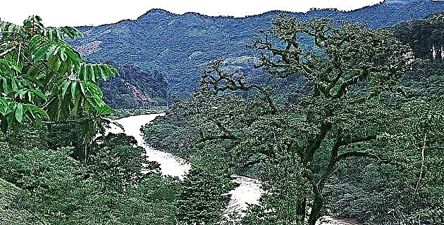
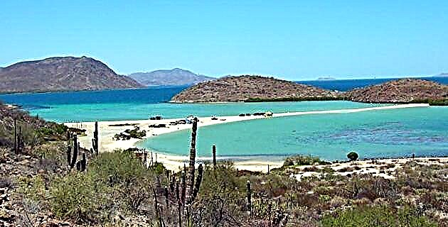
Among the arid mountains of the Sierra de la Giganta, the bay opens calm and majestic before the eyes of the visitor.
Among the arid mountains of the Sierra de la Giganta, the bay opens calm and majestic before the eyes of the visitor.
The night is very quiet and there is practically no noise, only the waves of the sea and the eventual commotion of some birds break the stillness for a moment. While we set up our camp, thousands of stars watch us from the sky and make us remember the words with which the Spanish explorer José Longinos described the Baja California night sky at the end of the 18th century: “… the sky is clear, the most beautiful I have seen, and with so many shining stars that, although there is no moon, it seems there is ... "
We had heard so much about this bay that it became almost an obsession to come and explore it; and today, after some time, we are finally here, in Bahía Concepción, on this moonless night that envelops us with its darkness.
THE GUYIAGUI VISIT
In his 18th century work, Noticia de la California, Father Miguel Venegas says that “The sun, the moon and the stars are men and women. Every night they fall into the western sea and are forced to swim to the east. The other stars are lights that Guyiagui lights in the sky. Although they are extinguished by sea water, the next day they are turned on again in the east ... ”This Guaycura legend tells how Guyiagui (the Visiting Spirit), representative of Guamongo (the Principal Spirit), traveled through the peninsula planting the pitahayas and opening the places for fishing and the estuaries of the Gulf of California; Once his work was finished, he lived among the men in a place known today as Puerto Escondido, south of Loreto, near Bahía Concepción, and later returned to the north, where he had come from.
DISCOVERING THE BAY
The sunrise is really incredible; the mountains of the Concepción peninsula, as well as the islets, are backlit by the red sky that shades the water of the very calm bay and offer us a formidable view.
We head towards the northern part of the bay; Throughout the morning we were walking and getting to know the surroundings; now we are at the top of a small hill that is located in a place called Punta Piedrita.
Observing the bay from above, one thinks how curious it is to be in a place that has remained almost unchanged since the first Spanish explorers became aware of its existence.
It happened that during the first exploration trip to the Sea of Cortez, in 1539, Captain Francisco de Ulloa directed his boats, the Santa Águeda and the Trinidad, heading south, fulfilling the task of marking everything that he found in his path to be able to Recognize the new territory, called Santa Cruz, taken into possession, in the name of the King of Spain, by Hernán Cortés years before, in 1535.
Ulloa overlooked this site, but Francisco Preciado, who was the senior pilot and captain of the Trinidad, after stopping for water a little further north, at a stream that years later would be called Santa Rosalía, cites him in his blog, and even indicates that they had to anchor there.
There were many subsequent expeditions to the Baja California peninsula, each one with particular purposes; but it was not until the third expedition led by Captain Francisco de Ortega that special interest was given to this bay.
Ortega's expedition was more interested in finding pearl feeders than in demarcating the new territory; Departing in their frigate Mother Luisa de la Ascensión, the expedition members headed for the peninsula; the trip, however, was not without incident; shortly before reaching the port of La Paz, in a place they called Playa Honda, probably near Pichilingue, they were surprised by a storm that caused them to shipwreck.
Forty-six days it took them to build another "masthead ship" (as Ortega called it) to continue with his company; Without weapons or gunpowder and only with what they could rescue from the wreckage of their boat, they continued on. On March 28, 1636, after arriving at Bahía Concepción, Ortega describes the event as follows: “I register another feeder and fishery for these pearls in a large bay that borders the sea with the mainland, which this bay will have From end to end six leagues, and all of it is dotted with mother-of-pearl shells, and at the end of this bay to the band of the host on the mainland, there is a great settlement of Indians, and I call it Our Lady of the Concepción, and has a background from one breaststroke to ten ”.
The captain and his people returned in May to the port of Santa Catalina, in Sinaloa, from where they had departed. There is no news that Ortega has returned to Baja California; it disappears from the historical scheme of the seventeenth century and no more is known about it.
Later, in 1648, Admiral Pedro Porter y Cassanate was sent to explore this part of the peninsula, which he called “Ensenada de San Martín”, a name that would not last. In 1683 Admiral Isidro de Atondo y Antillón made a new trip in order to recognize these lands again, of which he again took possession, now in the name of Carlos II.
Here begins a new stage in the history of the peninsula, as parents Matías Goñi and the illustrious Eusebio Francisco Kino, both from the Society of Jesus, were with Atondo; the missionaries walked across the peninsula and set the tone for the Jesuit foray into Baja California. Kino made several maps of what was then not certain that it was a peninsula, using a good part of the toponymy assigned by Ortega.
When Juan María de Salvatierra arrived on the peninsula in 1697 with the purpose of founding a permanent population in a place called San Bruno, he first entered the bay because of a storm. He immediately explored the area and finding no good quality water seemed uninhabitable.
In August 1703, on the instructions of Father Salvatierra, Fathers Píccolo and Balsadua found the stream that they had sighted when entering Bahía Concepción; later, going upstream and led by the indigenous Cochimíes, they arrive at the place where the mission of Santa Rosalía de Mulegé would be founded. With many sacrifices, this mission was installed and only a titanic effort by Father Balsadua made it possible to trace a path that would link Mulegé with Loreto, the then capital of the Californias (incidentally, the section of the current highway that passes through here it takes part of the original stroke).
To conclude with this historical adventure, it is worth mentioning the enormous company of Father Ugarte, which consisted of manufacturing a ship, El Triunfo de la Cruz, with wood from the Californias, and traveling north to see if these lands actually formed a peninsula ; Bahía Concepción served as a refuge for him almost at the end of his journey, when Ugarte and his men were surprised by the strongest squall of all they had encountered on the road. Once anchored, they went to the Mulegé mission, where Father Sistiaga attended them; later they arrived in Loreto, in September 1721. All this and more happened in those then, when the Pacific Ocean was the South Sea; the Sea of Cortez was known as the Bermejo Sea; Baja California was considered an island and the calculation of the position where they were found was the responsibility of those who knew how to “weigh the sun”.
THE BEAUTIFUL UNDERWATER GARDENS
Bahía Concepción has several islands where pelicans, seagulls, frigates, crows and herons nest, among many other birds. We decided to spend the night in front of La Pitahaya island, at the foot of the Punta Piedrita hill.
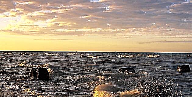
The sunset gives texture to the hills that, on the other side of the bay, extend unconquerable. At night and after the small campfire is consumed, we get ready to listen to the nocturnal sounds of the desert and to marvel at the phosphorescence of the sea that the slight hangover gives us; the fish in the water leap and fuss even more with the flashlight, making the moment truly incredible.
It dawns with that spectacular play of lights and tones; After a light breakfast we go into the water to enter a different world, full of life; stingrays pass by us unperturbed, and schools of multicolored fish swim through kelp forests that form an amazing underwater forest. A huge snapper peeks out shyly, keeping its distance, as if it had some suspicion of our presence.
A small group of tiny shrimp rushes past along with another group of fry, so small they look like transparent garbage with their own movement; a pair of white fish dart from one side to the other. There are anemones, sponges and catharine clams; the huge sea slug in vivid purple and orange hues rests on a stone. The water, however, is a bit cloudy due to the large amount of plankton that abounds here and that even produces a pinkish hue on the seashore.
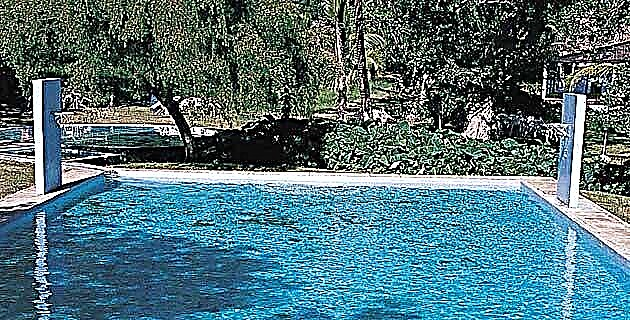
If you are lucky you can see sea turtles, and sometimes the dolphins venture into the bay. At El Coyote beach the water is warm and currents pass through there with a really high temperature. Near Santispac, behind the mangroves, of which there are many in this bay, there is a pool of thermal waters that gush at 50 degrees centigrade.
The sunset begins to unfold its spectacle, now with something else to offer us, a beautiful comet, a tireless traveler that flaunts its greatness in a sky full of stars; Maybe it is Guyiagui who says goodbye to us, as we have finished our tour. See you soon ...
Source: Unknown Mexico No. 285 / November 2000