Just 30 km south of the city of Puebla, in an area with a rugged and contrasting climate, not very vigorous in relief and where development has not yet reached, there is a community that does not appear on the maps, belonging to the municipality of Santa María Tzicahacoyan: San José Balbanera.
Just 30 km south of the city of Puebla, in an area with a rugged and contrasting climate, not very vigorous relief and where development has not yet reached, there is a community that does not appear on the maps, belonging to the municipality of Santa María Tzicahacoyan: San José Balbanera.
The white and ancient sea beds, today emerged, covered with mesquite, huizache, palmilla, nopal, soyate, maguey and biznaga dominate the landscape, and reflect as a mirror the incessant ray of the Sun that calcines the land, including the meager cultivation of corn from temporary and some heads of goats; their cowbells and bleating are the only resources that interrupt the ghostly silence of Balbanera.
However, a kilometer and a half to the southwest, the earth offers us a miracle: El Oztoquito Resumidero (from Nahuatloztoque, which means cave). With our backpacks and sacks of ropes we walk on a slight slope that later becomes horizontal until we find, just in contact with the basaltic and limestone rocks, the bed of an important now dry riverbed, which heads towards a depression where the vegetation it is more abundant.
As we descended, the great layers of bare limestone appeared in all their magnitude and the temperature, once warm, was now very pleasant and even cold. We leave the backpacks, and as usual, we dedicate ourselves to observing the characteristics and technical difficulties that each new cavity we visit may present.
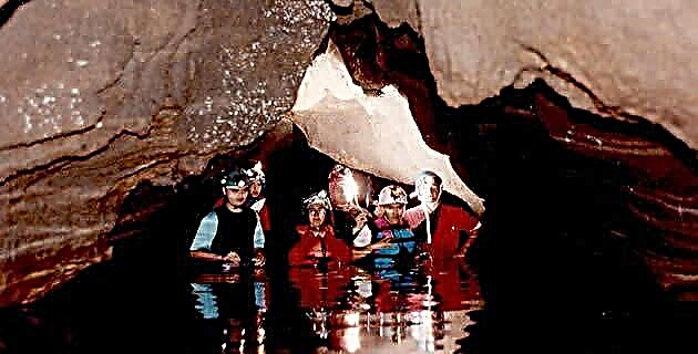
With a semicircular mouth, approximately 20 m in diameter, El Oztoquito has a series of ledges on its south side, from where the initial part of the 122-meter entrance shaft can be seen. We went down the riverbed between large blocks, until we reached a small shaded space with pools of stagnant water, where we decided to set up our precarious camp. Some peasants asked us if it did not bother us that their animals come down to drink water, since it is the only place where they can do it. After eating and drinking enough liquid we proceeded to equip ourselves. A small de-escalation along the same channel between polished blocks brought us closer to the edge of this abyss, located at an altitude of 1970 m.
It was an impressive sight to see the river that forms in the rainy season, as well as the waterfall that rushes into it with a great roar, which has thus excavated its entrails for thousands of years, shaping this geological phenomenon. It is the blood of the earth that nourishes your heart, in an eternal cycle of life.
A three-eighths spit (expansive piece of steel) is the main anchor that allows the rope to be attached. At 5 m it splits to reach a small ledge where we carry out a second split and 10 m further down a third on an 8 mm spit, before taking the vertical that would lead us to the bottom.
The conductive tube is oval in shape with about 10 m in diameter; It has dark and damp walls, and it maintains the same dimensions throughout. The faint rays of light are reflected in the water mirror that makes up the lake at the end of the descent, being forced for the first to go down the dip in a body of frozen water, with a depth of 1.70 m, before gaining the shore that it is located about 5 m further.
Once in the Sala de la Campana, a place of fine sand where you can camp, the cavity offers two interesting branches. To the south, the Los Hongos branch, with a length of 372 m, leads through a series of pools with crystalline waters and a labyrinthine zone of landslides, where the explorer must de-escalate towards a muddy terminal siphon. The White Tunnel stands out for its beauty in this branch. The north branch, with a length of 636 m, is wider and offers us the Paso de la Fuente, a beautiful pool of more than 3 m in depth and 25 in length. Later we observe a large number of transparent water bodies and areas of sand until ending in the Alto Sifón.
The El Oztoquito Resumidero was discovered in September 1986 by members of the Draco Base Association, who have systematically explored and surveyed it, with the aim of physically connecting another nearby cavity through the Alto Siphon, located 1 000 m away in north direction, called El Oztoque, which also has a final siphon. Diving in these cold waters has reached 74 m of maximum horizontal penetration, and according to the calculations of surface topography, it is necessary to add around 40 m to achieve the connection, which would be the first ever made in caving by Mexicans.
The flooded landscape measures on average 5 m wide by 3 m high and no concretions are observed. At 30 m an air hood where five people can stand up allows a technical break. The waters are crystal clear and visibility is good, but beyond 74 m the gallery continues and the unknown persists, and it will be the creepers who will one day clear it.
Meanwhile, and for those who want to admire a beautiful cavity or practice cave diving just 120 km from Mexico City, we invite you to get to know El Oztoquito and to explore the bowels of our underground Mexico.
INFORMATION FOR SPELEOLOGISTS
The Oztoquito originated from a vertical fracture within the limestones of the Lower Cretaceous Zapotitlán formation, and is covered by tertiary volcanic deposits from the Mesa Central and the Neovolcanic Axis. The cavern is located in the northwestern limit of the geological depression known as the Tlaxiaco basin, belonging to the physiographic province called Mixteca Oaxaqueña.
Its first part is of vadose origin, until it intercepts the stratification planes and develops its galleries at the water table. Its total length is 1078 m and its depth is 124 meters.
It is found on the topographic chart delinegi1: 50,000 E14B53 “San Francisco Totimehuacán”, at coordinates 18 ° 50’00 ’’ north latitude and 99 ° 05’30 ’’ west longitude. In the letter it is indicated as Resumideros de los Oztoques.
IF YOU GO TO EL OZTOQUITO
From the Federal District, arrive in the city of Puebla and head to Valsequillo. Cross the curtain of the “Manuel Ávila Camacho” dam and continue for another 6 km on the road that goes to Tecali. Take a left on a dirt road that indicates Tepanene and after 8 km you will reach San José Balbanera. There are several paths, so it is convenient to go during the day.
Source: Unknown Mexico No. 256 / June 1998