It is dawn and the horizon begins to give the first glimpses of clarity. Gone are the overwhelming Cumbres de Maltrata with its lines of heavy trucks and the Kaffirs that defy death in the curves drawn by the abyss.
We have also passed the case of Esperanza and the towns Atzizintla and Texmalaquilla. Now our vehicle ascends the dirt road that leads to the slopes of the Atlitzin and Citlaltépetl volcanoes. The road, in some sections, has cracks that in the rainy season would be an insurmountable obstacle; however, we continue until just over 3,500 m asl where we stop the car to start the ascent on foot. Rubén, who has known the area for 15 years (although I did not suspect that the Atlitzin was so high), guides me towards the north face of the mountain.
As the day progresses, the first rays of the sun paint the eastern slopes of Pico de Orizaba and the grasslands of Sierra Negra or Atlitzin volcano (Nuestra Señora de la Agüita) golden.
The morning is very clear when we pass through a forest whose vegetation has ceased to be dense for several years. In front of the voluminous felled pines that we found on the way, Rubén explains that their roots were dug up and cut so that they fell apart. Thus, the loggers claim not to have intervened in its fall; They affirm that the tree fell “for being old”, and they wield axes and saws to dismember it.
The indignation and sadness caused by the deterioration of the forest are offset by the landscape. On its southeastern slopes, the Pico de Orizaba shows the remains of a rather eroded chimney, known to mountaineers as Torrecillas: Next to it, with the zoom of the camera, I can see a red dot; the southern hostel of Citlaltépetl. At first glance it is also possible to contemplate the path that ascends to the shore of one of the great lava flows.
During the ascent to Atlitzin we see how gradually the vegetation becomes increasingly scarce. At an altitude of more than 4,000 m some pines still survive; however, the prevailing vegetation is grasslands and other high mountain plants. Suddenly, a natural arrangement of yellow flowers and gray buds surprises us on a bed of reddish stones. Elsewhere, next to whimsical igneous rocks, a mountain thistle blooms like a parched sunflower. Other stones are covered with a layer of green or red lichens where some insects usually inhabit.
At just over 4,500 m above sea level, we reach one of the shoulders of the Sierra Negra from where we can see, to the east and southeast, the low mountains of Veracruz, the Sierra de Zongolica and some valleys. Towards the south towards Tehuacán, you can see the Sierra de Tecamachalco and towards the north the Pico de Orizaba. From this point you can perfectly admire, on the slopes of Citlaltépetl, an enormous volcanic rock tongue next to Cerro Colorado, and due to the size of the pine trees on its banks, we calculate that such runoff cannot be less than 100 m in height high. How wonderful it would have been to contemplate, in a night scene, that lava descending vertiginously down the slopes!
We continue on our way worried about the clouds that are beginning to cover the summits of both Citlaltépetl and Atlitzin, but the last pull is particularly hard. In one of the breaks, Rubén takes the opportunity to photograph the Tepoztécatl hill, to the east, through a window that the clouds offer him for just a few moments. From now on, the mountain could well represent a Martian surface. In time immemorial, millions of years ago, perhaps an earthquake caused the eroded walls on the south side to collapse, which can be seen when the fog leaves the Cumbres de Maltrata from San José Cuyachapa.
A few meters before reaching the top we see three little crosses. The vestiges of the eroded crater appear and disappear in the white envelope of the clouds that like ghosts dwell there. One of the crosses is dedicated to the Sacred Heart of Jesus, the other is dedicated to the poet of the mountain, a character who climbed the volcano to find his muse, and the smallest has its room in the shape of a mound where there is a statuette of plaster with offerings and necklaces. The fog covers us slowly, and while we wait for the clouds to move, Rubén falls asleep and I doze for moments. Suddenly, a ray of sunlight interrupts my rest and the Citlaltépetl is stripped of clouds for a moment. However, the landscape towards the west remains cloudy and denies us the vision of Popocatépetl and Iztaccíhuatl.
Before starting the return, I look towards the collapsed crater of the Sierra Negra or Atlitzin volcano, which is neither more nor less the fifth summit of the country.
We do the descent in a calm way; In a house in Texmalaquilla they offer us food and in San José Atlitzin we satisfy our photographic restlessness. In its semi-deserted alleys, the dust raised by a flock of sheep herded by a young man is not enough to hide the bulk of the Atlitzin. The farewell is silent.
SIERRA NEGRA: THE UNKNOWN VOLCANO
Text: Rubén B. Morante
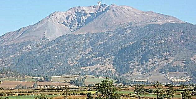
If I told you that the fifth summit in Mexico has gone unnoticed by geographers, would you believe me? It is a higher mountain than Malinche, Nevado de Colima and Cofre de Perote; However, if we try to locate it in geography books, we will see that in the vast majority of them it does not even appear. Its height, according to the INEGI chart 1: 50000, corresponding to Orizaba (E14B56), is 4 583 m above sea level, with which it is placed 120 m above La Malinche, a volcano that is considered the fifth peak of the country and now would happen to occupy the sixth position. Perhaps being very close to the highest peak of the Mexican territory is the reason for which it remains ignored. Only its close neighbor, Pico de Orizaba, together with Popocatépetl, Iztaccíhuatl and Nevado de Toluca surpass it in altitude.
We believe that this commission should be corrected, because as we will see later it is a totally independent massif from the Citlaltépetl, and not only was it formed in a different time but its eruptions threw different materials. We are talking about the Atlitzin volcano, better known as Sierra Negra or Cerro La Negra, located in the state of Puebla, although its slopes reach the Veracruz territory.
The Atlitzin volcano, better known as Sierra Negra or Cerro La Negra, receives this second name because seen to one side of the white snows of Pico de Orizaba, it appears to be a darker mass than it really is. It is a highly eroded crater that is part of one of the important binary volcano systems located in the Neovolcanic Axis or Sierra Volcánica Transversal, of which the main mountains of our country are part. It was formed before the Citlaltépetl, at the end of the Miocene. For this reason, it cannot be considered a secondary chimney of the Pico de Orizaba, from which it is clearly separated by an extension of land with a slight slope that starts at 4,000 m asl and constitutes the southern skirt of the Citlaltépetl. On this slope, slightly to the west, a parasitic cone appears, that is, a secondary channel of the Pico de Orizaba, which is known as Cerro Colorado and has a height of 4,460 m. Such a hill, we agree, does not constitute an independent elevation.
The Sierra Negra crater has suffered a process of erosion so severe that it has lost the walls of its chimney. In his important study of Pico de Orizaba carried out earlier this century, geologist Paul Waitz says that the Sierra Negra was formed through a long process, and during this period the wide crater of the original eruption was filled with lava. of a later spill, which in turn was the basis of a new one as where the process was repeated, raising the volcano more and more. The mountain chain of which the Sierra Negra is the southernmost summit, goes from south to north, reaches the Cofre de Perote and closes the Oriental Basin, preventing the exit of rivers and streams from the Puebla valley towards the Gulf of Mexico .
The Sierra Negra is within what used to be the Pico de Orizaba National Park, and we say outside because due to human settlements and the brutal exploitation of its forests it has lost more than half of its original 19,750 ha, which places it below the minimum 10,000 ha for a national park established by the un at the Second World Conference on National Parks in September 1972.
The climate in the Sierra Negra is cold semi-humid and its temperatures can range from 10ºC to 20ºC. During the winter the snow often turns it into a “white mountain range”, but in the spring the gray sand and igneous rocks give it back the physiognomy that gave it its name. The vegetation is basically made up of shrubs and pinnaceous trees, among which the pines of the bartwegii species dominate, at altitudes that exceed 3,800 m. We also find thistles (holy thistle) grasslands (called zacatones) and attractive flowering shrubs such as jarritos and elamaxbuitl. Only mosses and lichens prevail at the summit, and among the fauna there are some rabbits, coyotes, squirrels, foxes, rattlesnakes, lizards and birds such as crows and hawks.
Source: Unknown Mexico No. 217 / March 1995