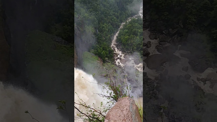
A few months ago, members of the Cuauhtémoc City Speleology Group (GEL), Chihuahua, invited me to organize a rappelling descent down the rocky wall of the Basaseachi waterfall, the highest in our country and reputed to be a one of the most beautiful in the world. The matter interested me a lot, so before getting fully into the preparation of said descent, I dedicated myself to looking for information about the site.
The oldest reference that I found about this spectacular waterfall dates from the end of the last century, and it appears in the book The Unknown Mexico of the Norwegian explorer Karlo Lumholtz, who visited it during his tours of the Sierra Tarahumara.
Lumholtz mentions that "a mining expert from Pinos Altos who has measured the height of the waterfall, found it to be 980 feet." This measurement passed to meters gives us a height of 299 m. In his book, Lumholtz briefly describes the beauty of the site, as well as presenting a photograph of the waterfall taken in 1891. In the Chihuahua Geographical and Statistical Review, published in 1900 by the C. Bouret Widow's Library, he is assigns a drop of 311 m.
Fernando Jordán in his Crónica de un País Bárbaro (1958) gives it a height of 310 m, and in a state monograph edited by the "La Prensa" bookseller in 1992, it is given a magnitude of 264 m. I found many more references about the waterfall and in most of them they say that its waterfall measures 310 m; some even mentioned that it measured 315 m.
Perhaps one of the most credible books I found was National Parks of Northeast Mexico by the American Richard Fisher, published in 1987, where it is mentioned that the geographer Robert H. Schmidt measured the waterfall and assigned it a height of 806 feet, or 246 feet. m. This last data places Basaseachi as the twentieth waterfall in the world and the fourth in North America.
Faced with such a discrepancy in the measurements, I proposed to the members of the GEL that we take advantage of the descent we are talking about to measure the height of the waterfall and thus get rid of doubts about this data; the proposal that was accepted immediately.
THE CIUDAD CUAUHTÉMOC SPELEOLOGY GROUP
The invitation to this descent seemed interesting to me since it was made by one of the oldest and most solid speleological groups in Mexico, with whom I was interested in sharing experiences and explorations. This group began in 1978 under the initiative and enthusiasm of several hikers and explorers from Cuauhtémoc, who made their first objective to make the descent to the beautiful Sótano de las Golondrinas, in San Luis Potosí (objective achieved with great success). Dr. Víctor Rodríguez Guajardo, Oscar Cuán, Salvador Rodríguez, Raúl Mayagoitia, Daniel Benzojo, Rogelio Chávez, Ramiro Chávez, Dr. Raúl Zárate, Roberto “el Nono” Corral and José Luis “el Casca” Chávez, among others, were the beginning and The driving force behind this group that has continued to be active in its explorations and journeys, motivating and promoting knowledge of the geographical beauties of the state of Chihuahua. In addition, it is a pioneer in all the northern states of the country.
We finally left Cuauhtémoc for Basaseachi on the afternoon of July 8. We were a large group, 25 people, since we were accompanied by the relatives, wives and children of several of the GEL members, because this excursion can combine very well with the family due to the existing facilities in Basaseachi National Park.
THE ADVENTURE BEGINS
On the ninth we got up from 7 a.m. to carry out all the preparations for the descent. With the ropes and equipment we moved to the edge of the waterfall. Thanks to the rains that have fallen heavily in the mountains, it carried a considerable volume of water that fell dramatically towards the beginning of the Candameña canyon.
We decided to establish the main descent line at a point that is about 100 m above the right of the viewpoint, and about 20 m above the waterfall. This point is excellent to go down, since except for the first 6 or 7 m, the fall is free. There we put a 350 m long cable. We call this the GEL route.
Although the GEL route is quite good and presents beautiful views of the waterfall, we decided to establish another descent line that was closer to the torrent in order to get more photographic advantage of the waterfall. For this, we only found one option that was about 10 m from the start of the waterfall. The descent from this part is fine, only that from the middle of the fall the route was covered by the water jet, since it expands as it descends.
On this second route, we anchor two cables, one of 80 m which is where the explorer who would act as a model would descend, and another of 40 m through which the photographer would descend. This path did not reach the bottom of the waterfall and we call it the “photographic route”.
The first to make the descent was the young Víctor Rodríguez. I checked all his equipment and accompanied him at the start of his journey. With great serenity he began to descend and little by little he was lost in the immensity of the fall.
In the background we had a small lego and the beginning of the Candameña River that winds through the vertical walls of the canyon of the same name. After Víctor, Pino, Jaime Armendáriz, Daniel Benzojo and Ramiro Chávez came down. The descent in rappelling in falls of a certain magnitude like this, we do it with a simple and small device that we call “marimba” (because of its resemblance to said musical instrument), which is based on a principle of friction on the cable.
The marimba allows the intensity of friction to be varied in such a way that the explorer can easily control the speed of its descent, making it slow or fast as desired.
Before Víctor finished his descent, Oscar Cuán and I began to go down the two lines that we had placed on the photographic route. Oscar was the model and I was the photographer. It was truly impressive to descend next to the huge stream of water and see how it fell with force and hit the rocky wall.
THE GOLDEN RULES
Like 6 p.m. We finished the work for that day and prepared a rich and abundant discada (a very Chihuahuan country meal) as dinner. Since most of the GEL friends were accompanied by their wives and children, we had pleasant moments of conviviality with them.
I was very pleased to see how well integrated the GEL is and the support it receives from its families. In fact, his philosophy is summarized in three basic rules of love for nature: 1) The only thing that is left are the footprints. 2) The only thing that kills is time. 3) The only thing that is taken are photographs.
They have told me that on several occasions they have reached very remote places that are intact and when they leave they take all the garbage, trying to leave them the same as they found them, clean, intact, in such a way that if another group were to visit them , I would feel the same as them; that no one had ever been there before.
On July 10, the last day of our stay in the park, several people would go down the GEL route. Before starting the maneuvers, I picked up the 40 m cable from the photographic route and placed it on the GEL route in order to be able to make some descents better and to take better photographs. The first to go down was José Luis Chávez.
However, a few minutes after starting his descent he yelled at me and I immediately went down the 40 m cable to where he was, which was 5 or 6 m below the shore. When I got to him I saw that the cable was rubbing hard on the stone that had already broken all the protective lining and was beginning to affect the core of the rope; the situation was extremely dangerous.
Before we started operations that day I had checked the first few meters of the cable precisely to detect any possible friction, however, the one we had at that time could not be seen from above. José Luis had not seen the rub until he had already passed through it, so he immediately placed a self-insurance on top of the rub, and began the maneuvers to return.
When we both got on and disconnected from the cables, we hoisted the grazed part and resumed. The friction had been produced by a discreet but sharp protrusion that could not be avoided, so we placed a chassis to avoid new friction on the rope. Later he finished his descent without major problems.
Right after José Luis, Susana and Elsa came down, both daughters of Rogelio Chávez, who is an enthusiast in hiking and exploring, and encourages them a lot. They must be between 17 and 18 years of age. Although they had rapped before, this was their first important descent and they were very spirited, very supported by their father, who was the one who checked all their equipment. I went down the 40 m rope with them to help them in the first part and to take a photographic sequence of the descent.
After Elsa and Susana, Don Ramiro Chávez, their paternal grandfather, descended. Don Ramiro is, for many reasons, an exceptional person. Without fear of being wrong, he was without a doubt the youngest person who came down the waterfall, and not precisely because of his age since he is 73 years old (which it does not seem), but because of his spirit, enthusiasm and his love of life.
Once Don Ramiro came down, it was my turn. As I went down, with a clisimeter I set the level of the rope at the exact point where the waterfall started and I left a mark in order to be able to accurately measure the magnitude of the waterfall. I kept going down and all the time I had before me the vision of the fall, what a wonderful sight! I had to see several rainbows that are formed by the breeze that escapes from the stream of water.
When I reached the bottom, Cuitláhuac Rodríguez began his descent. While I was waiting for him, I was ecstatic with the spectacle that I had at my feet. When falling, the waterfall forms a lake that is difficult to get close to because it is always subject to the force of the breeze and wind. There are large rocky blocks product of millenary landslides and everything is covered with grass and a very beautiful deep green moss in a radius of about 100 m. Then there is the forest, dense and beautiful thanks to the fact that it has not been subject to human predation.
When Cuitláhuac arrived, we began to go down the rivers, since we had to cross it to take the path that goes up to the top of the waterfall. However, the crossing cost us some work because the channel was somewhat overgrown and continued to grow. Climb the vertical and go between huge pines, táscates, alders, strawberry trees, oaks and other beautiful trees.
It was 6 p.m. when we get to the top; All the cables and equipment had already been collected and everyone was in the camp, lifting it up and preparing the farewell dial. If something caught my attention, it was that GEL members like to eat well, and I'm more used to “faquireadas”.
Once we finished eating we proceeded to measure the descent cable between the marks that had been placed in order to know the exact measure of the waterfall of the Basaseachi waterfall. This turned out to be 245 m, which agrees with the measurement reported by geographer Schimdt of 246m.
Before heading back to Cuauhtémoc, I went to say goodbye to the waterfall, to once again admire its beauty and to give thanks because we were allowed the privilege of being with it and enjoying it to the fullest. The rain had already stopped for a long time and from the bottom of the valley and the canyon a fog was slowly rising that blended with the breeze.