For a long time painting and cartography maintained a close relationship, since in the workshops painters worked both on maps and on drawings.
For a long time painting and cartography maintained a close relationship, since in the workshops painters worked both on maps and on drawings. The great artists of the Renaissance were also busy making cartographic charts, including Dürer and Da Vinci. The discovery of the geometric perspective projection then developed in art was applied very early to the representation of cities to simulate the volume and degree of distance of the viewer in order to achieve a naturalistic effect.
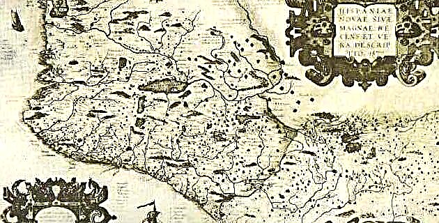
As for Mexico, during the Conquest and the beginning of the Colony a syncretism between the pre-Hispanic and Spanish forms took place in the cartography of the city. However, many doubts remain as to whether a plan was made with the design of what would be the new city after the destruction of Mexico Tenochtitlán, since no one mentions it or there is a trace of it; what there is news about is his direct line on the ground. An interesting anonymous is the so-called Das alte México, a German version of the city of Mexico-Tenochtitlán, following the plan of Pierre Bertius, which recalls the old European walled populations of that time.
There is also news that in 1573 the city council ordered a plan of the ejidos, but it is unknown if it was carried out, although it is deduced that letters of the city had to be made during the first colonial period and then they were not preserved. Its characteristics can be inferred from two plans of the Plaza Mayor, by Francisco Guerrero, which are preserved from then on, one from 1562 or 66 and the other from 1596.
This type of plan presents, in the space of each property, the main facade of the houses folded backwards and the houses lined up one after another forming streets. The result is a combination between the spaces of the squares and streets, as if they were seen from above while the facades are projected in elevation. Neither of them produce the appearance of depth that vertical perspective does.
It was in the seventeenth century when the perspective in the cartography of the capital of the Colony was completely introduced and its prototype was the Forma y raised plan of Mexico City, made entirely with a European technique by Juan Gómez de Trasmonte in 1628, the which covers the city and Lake Texcoco from west to east; document that constitutes the first complete image of the capital of the viceroyalty. In it, all urban parts such as streets, squares, aqueducts, ditches and buildings are detailed with volume.
When comparing it with others, the specialists point out several errors in the proportions of certain squares, omission of some blocks located east of La Alameda and other details, although it is indisputably a magnificent image of what the city was like at the beginning of the 17th century and despite Of all, this plan would serve as a model for other futures. However, the beautiful watercolor copper engraving entitled Vue de la Ville du Mexique prize du coté du Lac, published by Daumont, which dates from 1820, shows the city with buildings and squares in the European way. and with a curious interpretation of the chinampas.