For almost three centuries the mines of New Spain were owned by Creoles or Spaniards residing in Mexico, and it was not until the first years of independent life that foreign capital was allowed to enter Mexican mining.
Thus, at the end of the 19th century, British, French and mostly North American companies were operating in the states of Zacatecas, Guanajuato, Hidalgo, San Luis Potosí and Jalisco, among others.
Some companies resume the exploitation of old mines, others acquire land in several states, and still others, in their search for new deposits, explore the most remote regions of the country and establish themselves in almost inaccessible sites that, with the passage of time, finally they are abandoned. One of these sites - whose history is unknown - is the Santa Fe mine, in the state of Chiapas.
For most of the inhabitants of the region the place is known as "La Mina", but no one knows for sure what its origin is.
To go to the mine we take a path that begins in El Beneficio, a community located on the banks of federal highway no. 195, in the foothills of the northern highlands of Chiapas.
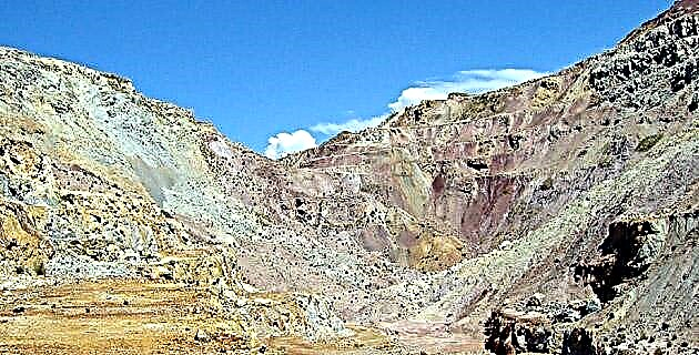
The main entrance to Santa Fe is a cavity 25 meters high by 50 meters wide, carved out of the living rock of a mountain. Its magnitude and beauty are exceptional, to such an extent that they lead us to believe that we are in a natural cavern. Other rooms are accessed from the main cavity and from these several tunnels lead to the interior.
We have about twenty open tunnels on four levels, all of them unarmed, that is, they are not supported by beams or boards, since they are drilled into the rock. Some seem extensive, others are small sinkholes and blind tunnels. In a rectangular chamber we find the mine shaft, which is a vertical shaft through which people, tools and materials were mobilized at other levels by means of cages. A look inside reveals that at eight or 10 meters the lower level is flooded.
Although the mine has certain similarities to a cavern, its exploration offers greater risks. During the prospecting we found cave-ins in several tunnels. In some the passage is completely obstructed and in others partially. To continue exploring it is necessary to cautiously slide through a gap.
These galleries measure an average of two meters wide by another two meters high and it is common for them to be flooded, since landslides function as dams and infiltration water is deposited in long stretches. With the water up to our waist, and sometimes up to our chest, we go through a maze where flooded sections and dry sections alternate.
On the ceilings we discovered calcium carbonate stalactites two centimeters long and hangings half a meter long on the walls. Even more striking are the emerald green and rust red stalactites, gushings, and stalagmites formed by runoff from copper and iron ores.
When inspecting the surroundings, Don Bernardino tells us: "follow that path, cross the bridge and on the left you will find a mine called La Providencia." We take the advice and soon we are on the threshold of a large room.
If the Santa Fe mine It is worthy of admiration, La Providencia surpasses everything imagined. The room is of colossal proportions, with a floor made up of several levels, from which tunnels and galleries start in different directions. It is worth noting the La Providencia shot, a solid and beautiful masonry work with thick walls and Roman-type arches, four times the size of Santa Fe.
Pedro Garcíaconde Trelles estimates that the current cost of this construction exceeds three million pesos, which gives us an idea of the strong investment that the company made in its time and the expectations placed on the deposits.
We estimate that there are almost two kilometers of tunnels throughout the complex. Due to the volume of material extracted, it is to be assumed that this is the oldest mine, and if we consider that the galleries and cavities were opened with a hammer and bar, and that each “thunderstorm” –that is, the explosion of a charge of gunpowder - allowed the miners a meter and a half advance in the rock, we can imagine the magnitude of the effort deployed.
The more we study the place, the greater the questions. The vastness of the work suggests a long-term project that required an entire army of men, technical personnel, machinery, implements and an infrastructure to process the mineral.
In order to clear up these unknowns, we turned to the residents of El Beneficio. There we are fortunate to meet Mr. Antolín Flores Rosales, one of the few surviving miners, who agrees to be our guide.
"According to old miners told me, Santa Fe belonged to an English company," explains Don Antolín. But no one knows what time they were here. It is said that there was a very large flood in which many people were trapped and that is why they left. When I arrived in Chiapas in 1948, here it was an authentic jungle. At that time the La Nahuyaca company had been established for three years and exploited copper, silver and gold.
They brought qualified personnel and rehabilitated some of the English buildings, drained the shafts, built a road from the mine to El Beneficio to transport the mineral, and rehabilitated the road to Pichucalco. As I had experience from having worked in several silver mines in Taxco, Guerrero, I began to work as a railroad operator until May 1951, when the mine stopped operating apparently due to problems with the union and because the maintenance of the roads had already it was unaffordable ”.
Don Antolín takes out his machete and with unusual agility for his 78 years, he enters a steep path. On the way up the hillside we see the entrances of several tunnels. "These tunnels were opened by the Alfredo Sánchez Flores company, which worked here from 1953 to 1956," explains Don Antolín, "then the Serralvo and Corzo companies arrived, working for two or three years and retiring due to their inexperience in the business.
Those of the Mining Development team explored some tasks until the mid-seventies, when everything was abandoned ”. The guide stops in front of a hole and points out: "This is the Copper Mine." We light the lamps and go through a maze of galleries. A strong current of air takes us to the mouth of a 40 meter deep shot. The pulleys and winch have been dismantled decades ago. Don Antolín recalls: “Two miners were killed nearby in a shot. A mistake cost them their lives ”. A tour of other galleries confirms that we are on the first level of Santa Fe.
We retrace the road and Don Antolín leads us to a wooded area located between Santa Fe and La Providencia, where we find buildings scattered over two or three hectares. They are the buildings attributed to the English, all on one floor, with walls of rock and mortar four meters high by half a meter wide.
We go through the ruins of what used to be the warehouse, the rehearsal room, the mill, the flotation room, the concentrate furnace and a dozen other buildings. Due to its design and state of conservation, the smelting furnace, built with refractory brick and with a half-barrel vaulted ceiling, stands out, as well as the drainage tunnel that connects with the shaft of both mines, which is the only tunnel with beams and iron rails.
Who were its builders? It is Peter Lord Atewell who finds the answer: Santa Fe was registered in London on April 26, 1889, with the name of Chiapas Mining Company and a capital of 250 thousand pounds sterling. It operated in the state of Chiapas from 1889 to 1905.
Today, when touring the ancient buildings and tunnels carved into the mountain, we cannot help but feel admiration and respect for the men who worked on this great work. Just imagine the conditions and adversities they faced more than a century ago in a place completely removed from civilization, in the heart of the jungle.
How to get:
If you are traveling from the city of Villahermosa, Tabasco, you must go to the south of the state on federal highway no. 195. On your way you will find the towns of Teapa-Pichucalco-Ixtacomitán-Solosuchiapa and, finally, El Beneficio. The tour comprises 2 hours for an approximate distance of 100 kilometers.
Travelers leaving from Tuxtla Gutiérrez should also take federal highway no. 195, towards the municipality of Solosuchiapa. This route includes just over 160 km of highways, so it takes a 4-hour drive to get to El Beneficio. In this case, it is recommended to spend the night in Pichucalco where there are hotels with air conditioning service, a restaurant, etc.
mines in chiapasmines in Mexican mexicomineria