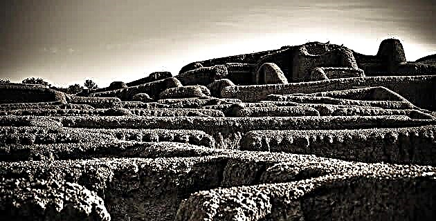
Much has been said about dinosaurs in recent times and we know that they inhabited various regions of the territory that is currently our country, although this was in such a remote past that when they became extinct, the Sierra Madre Occidental did not yet exist. It took millions of years for this great massif and with it the Sierra Tarahumara, to rise.
About 40 million years ago, during the Tertiary era, the northwestern region of what is now Mexico suffered from intense volcanism, a phenomenon that persisted for more than 15 million years. Thousands of volcanoes erupted everywhere, covering a vast area with their spills of lava and volcanic ash. These deposits formed large plateaus in the mountains, some of which reached an altitude greater than 3,000 m above sea level.
Volcanism, always associated with activity and tectonic movements, gave rise to large geological faults that caused fractures in the crust and generated deep cracks. Some of these almost reached 2,000 m in depth. With the passage of time and the action of water, rains and underground currents formed the streams and rivers that converged deep in the canyons and ravines, deepening them by undermining and eroding their channels. The result of all these millions of years of evolution and that we can now enjoy is the great system of Barrancas del Cobre.
Great ravines and their rivers
The main rivers of the sierra are found within the most important ravines. All those of the Sierra Tarahumara, with the exception of Conchos, drain towards the Gulf of California; its currents leave through the great valleys of the states of Sonora and Sinaloa. The Conchos River makes a long journey through the mountains, where it is born, then crosses the plains and the Chihuahuan deserts to join the Rio Grande and exit to the Gulf of Mexico.
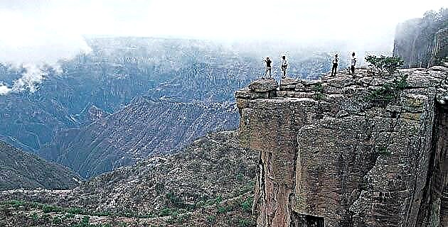
Much has been discussed about the depth of the world's ravines, but according to the American Richard Fisher, the Urique ravines (with 1,879 m), Sinforosa (with 1,830 m) and Batopilas (with 1,800 m) occupy the places worldwide. eighth, ninth and tenth, respectively; above the Grand Canyon, in the United States (1,425 m).
Majestic waterfalls
Of the most outstanding aspects of the Copper Canyon are its waterfalls, classified among the largest in the world. The Piedra Volada and Basaseachi stand out. The first one has a 45 m waterfall, it is the fourth or fifth largest in the world, and of course it is the highest in Mexico. The discovery of this waterfall is recent and is due to the explorations of the Cuauhtémoc City Speleology Group.
The Basaseachi waterfall, known for 100 years, has a height of 246 m., Which places it as number 22 in the world, the 11th in America and the fifth highest in North America. In Mexico it is the second. In addition to these two, there are many more waterfalls of considerable magnitude and beauty that are distributed throughout the mountain range.
Weather
Being so broken and abrupt, the ravines present different climates, contrasting and sometimes extreme, within the same region. In general, there are two environments that exist in the Sierra Tarahumara: that of the plateaus and mountains in the upper parts of the sierra and that of the bottom of the ravines.
At altitudes higher than 1,800 meters above sea level, the climate ranges from mild to cold most of the year, with light rains in winter and occasionally heavy snowfalls that give great beauty and majesty to the landscapes. Then temperatures below 0 degrees Celsius are recorded, which at times drop to minus 23 degrees Celsius.
In the summer, the mountains show their maximum splendor, the rains are frequent, the landscape turns green and the valleys are overflowing with multicolored flowers. The average temperature is then 20 degrees Celsius, very different from the rest of the state of Chihuahua, which is very high at this time of year. The Sierra Tarahumara offers one of the most pleasant summers in the entire country.
In contrast, the climate at the bottom of the Copper Canyon is subtropical and its winter is the most pleasant, as it maintains average temperatures of 17 degrees Celsius. On the other hand, in the summer season, the Barranco climate is heavy, the average rises to 35 degrees Celsius, and temperatures of up to 45 degrees Celsius have been recorded in the area. The abundant summer rains make the flow of waterfalls, streams and rivers rise to their maximum flows.
Biodiversity
The abrupt and steepness of the topography, with slopes so great that they can exceed 2,000 m in a few kilometers, and the contrasting climatic variations produce exceptional richness and biological diversity in the mountains. Endemic flora and fauna abound in it, that is, they are not found anywhere else in the world.
The plateaus are covered by extensive and beautiful forests where pine predominates, although oaks, poplars, junipers (locally called táscates), alders and strawberry trees also multiply. There are 15 species of pines and 25 of oaks. The majestic forests of Guadalupe y Calvo, Madera and the Basaseachi region offer us towards the beginning of autumn an extraordinary view, when the poplars and alders, before losing their leaves, acquire yellow, orange and reddish tones that contrast with the greenery of pines, oaks and junipers. In the summer the entire mountain range blooms and fills with colors, that is when the diversity of its flora is most exuberant. Many of the flowers, abundant at this time, are used by the Tarahumara in their traditional medicine and food.
There is a succession of plant communities from the middle heights of the sierra to the depths of the ravines where bushes proliferate. Various trees and cacti: mauto (Lysiloma dívaricata), chilicote (Erythrína flaveliformis), ocotillo (Fourqueria splendens), pitaya (Lemaíreocereus thurberi), cardón (Pachycereus pectenife), tabachín (Caesalpinia pulcherungaves (Aveígaves), gatugavesa (Mimra) lechugilla), sotol (Dasylirio wheeleri), and many other species. In the humid areas there are species such as ceiba (Ceiba sp), fig trees (Ficus spp), guamuchil (Pithcollobium dulce), reeds (Otate bamboo), burseras (Bursera spp) and lianas or lianas, among others.
The fauna of the Copper Canyon coexists in warm or hot habitats. Almost 30% of the species of terrestrial mammals registered in Mexico have been located in this mountain range, distinguishing themselves: the black bear (Ursus americanus), the puma (Felis concolor), the otter (Lutra canadensis), the white-tailed deer ( Odocoileus virginianus), the Mexican wolf (Canis lupus baileyi) considered in danger of extinction, the wild boar (Tayassutajacu), the wild cat (Lynx rufus), raccoon (Procyon lotor), the badger or cholugo (Taxidea taxus) and the striped skunk (Mephitis macroura), in addition to numerous species of bats, squirrels and hares.
290 species of birds have been registered: 24 of them endemic and 10 in danger of extinction, such as the green macaw (Ara militaris), the mountain parrot (Rbynchopsitta pachyrbyncha) and the coa (Euptilotis noxenus). In the more isolated parts, the flight of the golden eagle (Aquila chsaetos) and the peregrine falcon (Falco peregrinus) can still be seen. Among the birds are woodpeckers, wild turkeys, quail, buzzards, and mound. Thousands of migratory birds arrive in the winter, especially geese and ducks fleeing the intense cold of the northern United States and Canada. It also has 87 species of reptiles and 20 of amphibians, of the first 22 are endemic and of the second 12 have this character.
There are 50 species of freshwater fish, some of which are edible such as rainbow trout (Salmo gardneri), largemouth bass (Micropterus salmoides), mojarra (Lepomis macrochirus), sardine (Algansea lacustris), catfish (Ictalurus punctatus) , the carp (Cyprinus carpio) and the charal (Chirostoma bartoni).
Chihuahua al Pacifico Railroad
One of the most impressive engineering works carried out in Mexico is within the marvelous scenario of the Copper Canyon: the Chihuahua al Pacífico railway, inaugurated on November 24, 1961 in order to promote the development of the Sierra Tarahumara, providing Chihuahua an exit to the sea through Sinaloa.
This route begins in Ojinaga, passes through the city of Chihuahua, crosses the Sierra Tarahumara and descends to the coast of Sinaloa, via Los Mochis to end in Topolobampo. The total length of this railway line is 941 km and has 410 bridges of different lengths, the longest being that of Río Fuerte with half a kilometer and the highest that of Río Chínipas with 90 m. It has 99 tunnels that total 21.2 km, the longest are El Descanso, on the border between Chihuahua and Sonora, with a length of 1.81 km and the Continental in Creel, with 1.26 km During its route it rises to 2,450 meters above the level of the sea.
The railroad crosses one of the steepest regions of the mountain range, runs through the Barranca del Septentrión, 1,600 m deep, and some points in the Urique canyon, the deepest in all of Mexico. The landscape between Creel, Chihuahua, and Los Mochis, Sinaloa, is the most spectacular. The construction of this railroad was initiated by the state of Chihuahua in 1898, reaching Creel in 1907. The work was completed until 1961.