For many years I have been fortunate to be able to explore and travel many places that have never been visited by man.
These sites were always underground cavities and abysses that, due to their isolation and the degree of difficulty in reaching them, had remained intact; but one day I wondered if there would be some virgin place in our country that was not underground and that was spectacular. Soon the answer came to me.
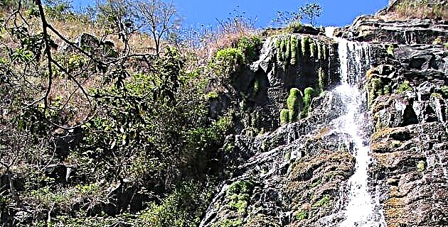
Some years ago, reading Fernando Jordán's book El Otro México, which deals with Baja California, I came across the following statement: “… vertically, on a cut that has no inclination, the stream of the Garzas gives a frightful jump and forms a imposing waterfall for its height. They are exactly 900 m ”.
Since I read this note I have been concerned about the real identity of said waterfall. There was no doubt that very few people knew about her, since nobody knew how to tell me anything, and in the books I only found the reference to Jordan.
When Carlos Rangel and I made the Baja California hike in 1989 (see México Desconocido, Nos. 159, 160 and 161), one of the objectives we set ourselves was to locate this waterfall. At the beginning of May of that year we reached the point where Jordán was 40 years ago, and we found an imposing granite wall that we calculated would rise vertically 1 km. A stream came down from a pass forming three waterfalls of about 10 m and then the pass would turn to the left and upwards at a dizzying pace, and it was lost. To be able to follow it you had to be an excellent climber and also have a lot of equipment, and since we were not taking it at that time, we gave up going up. Facing the wall, most of the pass through which the stream descends was not visible, since it runs parallel to the rocky front; only very high up 600, 700 or more meters was another waterfall that could hardly be distinguished. Jordán surely saw the waterfall from above and below and could not look out into the open either, so he assumed that there would be a large waterfall of 900 m. The ranchers in the area call that open the “Chorro Canyon”, and on that occasion we reached a beautiful pool where the last waterfall falls.
THE FIRST ENTRY
In April 1990 I decided to continue exploring the site to find out exactly what was inside the Chorro Canyon. On that occasion I organized an expedition through the upper part of the canyon, in which Lorenzo Moreno, Sergio Murillo, Esteban Luviano, Dora Valenzuela, Esperanza Anzar and a server participated.
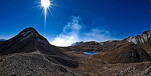
We left Ensenada and ascended to the San Pedro Mártir mountain range through the dirt road that goes to the UNAM astronomical observatory. We leave our vehicle in a place known as La Tasajera and in this same place we camp. At nine o'clock in the morning the next day we started the walk towards the source of the stream of the Chorro through a beautiful valley called La Grulla, which is surrounded by pine trees and does not give the feeling of being in Baja California. Here the stream of Chorro is born from several springs, which we continue at times surrounding the dense vegetation and sometimes jumping between the stones. At night we camped in a place we call the “Piedra Tinaco” and although the walk was heavy, we really enjoyed the landscape and the abundant view of flora and fauna.
The next day we continue the walk. Soon, the stream left the monotonous pace that it had in the Crane and began to show its first rapids and waterfalls, which forced us to take some detours between the surrounding hills, which were exhausting due to the dense rameríos and the heavy sun. At three in the afternoon a waterfall of about 15 m forced us to make a detour for about an hour. It was almost dark when we camped by the creek, but we still had time to catch some trout for dinner.
On the third day of hiking we started the activity at 8:30 in the morning, and after a while we reached an area where rapids and small waterfalls follow one after another and form beautiful pools where we stopped to swim. From this point, the stream began to gorge itself and the pines almost disappeared to give way to the alders, poplars and oaks. In some parts there were large blocks of granite between which the water was lost, forming some underground passages and waterfalls. It was 11 o'clock when we arrived before a 6 m waterfall that we could not turn around, not even over the hills, since here the stream is fully gutted and begins its vertiginous descent. As we did not bring cable or equipment to rappel, this is where we come. At this point we called it the "Head of the Eagle" due to a gigantic rock that stood out in the distance and seemed to have that shape.
During the return we take the opportunity to explore some of the lateral streams to the Chorro Canyon, check several caves and visit other valleys near La Grulla, such as one called La Encantada, which is a true wonder.
THE FLIGHT
In January 1991, my friend Pedro Valencia and I flew over the Sierra de San Pedro Mártir. I was interested in observing the Chorro Canyon from the air before starting the explorations of its interior. We flew over most of the mountain range and I was able to photograph the canyon and realize that it is essentially vertical. Later I was able to get a series of aerial photographs that some scientists in Ensenada had taken and I was able to draw a provisional map of the place. By now I had no doubt that no one had ever entered the Chorro Canyon. With the analysis of the aerial photos and the flight I did, I realized that just as far as we had advanced is where the vertical part begins; from there the stream descends almost 1 km in less than 1 km horizontally, to the point where Rangel and I reached in 1989, that is, the base of the sierra.
THE SECOND ENTRY
In April 1991 Jesús Ibarra, Esperanza Anzar, Luis Guzmán, Esteban Luviano Renato Mascorro and I returned to the mountains to continue exploring the Canyon. We had a lot of equipment and we were quite loaded since our intention was to stay in the area for more or less 10 days. We brought an altimeter and we measured the altitudes of the key places where we passed. The Grulla valley is at 2,073 meters above sea level and Piedra del Tinaco at 1,966 meters above sea level.
On the third day early, we arrived at Cabeza del Águila (at 1,524 meters above sea level) where we set up a base camp and divided ourselves into two groups to advance. One of the groups would open the route and the other would make it “cherpa”, that is, they would carry food, sleeping bags and some equipment.
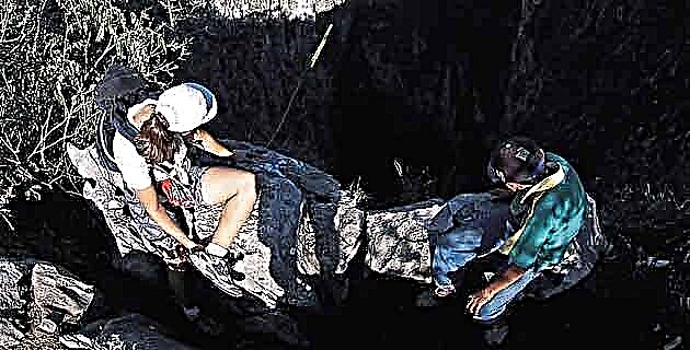
Once the camp was set up, we divided up and continued exploring. Armed the team in the waterfall that had been pending last year; has a 6 m drop. A few meters from there, we come to a large group of huge granite blocks, the product of a thousand-year-old collapse, which block the stream and cause the water to filter between the hollows in the rock, and inside it forms waterfalls and pools that, although small, they are of great beauty. Later we climbed a large block to the right and we prepared to go down a second shot of about 15 m of fall that ended right where the water of the stream comes out with great force from its underground route.
We continued our advance and shortly after we reached a waterfall much larger than all the ones we had seen until then (30 m), where the water falls completely into the gorge and descends in four jumps to a large pool. As there was no way to avoid it and it was not possible to rappel directly on it due to the great force that the water carried, we decided to climb one of the walls until we reached a point where we could descend without risk. However, it was already late, so we decided to camp and leave the descent for the next day. We call this waterfall the "Four Curtains" due to its shape.
The next day, Luis Guzmán and I made a descent down the right wall of the canyon, opening a route that allowed us to easily avoid the waterfall. From below the jump looked imposing and formed a large pool. It is a very beautiful and spectacular place that stands out in the arid landscapes of Baja California.
We continued descending and later we came to another waterfall in which it was necessary to install another cable of about 15 m. We call this part the "Collapse II", since it is also the product of an ancient collapse, and the stones block the canyon causing the water of the stream to rise and disappear several times between the gaps. Down there is a huge and beautiful pool that we name “Cascada de Adán” because Chuy Ibarra undressed and took a tasty bath in it.
After resting and being ecstatic with this remote site, we continued descending between rocky blocks, pools, rapids, and brief waterfalls. Soon after we started walking on a kind of ledge and the stream began to stay down, so we had to find a place to descend, and we found it through a beautiful wall with a vertical drop of about 25 m. Below this shaft, the stream glides smoothly over a granite slab in beautiful, smooth shapes. We call this place "El Lavadero", because we figured it was an idea to wash clothes by carving them on the stone. After the Lavadero, we found a small 5 m gap, which was actually a handrail to avoid a difficult passage with greater safety. Below this we camped in a nice sandy area.
The next day we got up at 6:30 A.M. and we continue the descent. A short distance away we found another small shaft of about 4 m and we quickly lowered it. Later we came to a beautiful waterfall about 12 or 15 m high that fell into a beautiful pool. We tried to descend on the left side, but that shot led us directly to the pool, which looked deep, so we looked for another option. On the right side we find another shot, which we divide into two parts to avoid reaching the water. The first part is 10 m of fall to a comfortable ledge, and the second is 15 m to one of the banks of the pool. The waterfall has a large stone in the middle that divides the water into two falls and because of this we named it the “Twin Waterfall”.
Immediately after the Twin House pool, another waterfall begins, which we estimate had a 50 m drop. As we could not descend directly on it, we had to make several crossings and climbs to avoid it. However, the cable had run out and our progress was interrupted. We saw that under this last waterfall there were at least two more, also large ones, and already far below the canyon was spinning in its vertiginous descent, and although we could no longer see beyond, we noticed that it was totally vertical.
We were very happy with the result of this exploration, and even before starting the return we began to organize the next entry. We returned slowly picking up the cable and the equipment, and as we planned to return soon, we left it hidden in several caves along the way.
THE THIRD ENTRY
By the following October we were back: we were Pablo Medina, Angélica de León, José Luis Soto, Renato Mascorro, Esteban Luviano, Jesús Ibarra and the one who writes this. In addition to the equipment that we had already left, we carried 200 m more cable and food for about 15 days. Our backpacks were loaded to the top and the trouble with this rugged and inaccessible area is that one has no option of using donkeys or mules.
It took us approximately five days to reach the last point of advance in the previous exploration, and unlike the last time when we were leaving the cables, now we were picking them up, that is, we no longer had the possibility of returning the way we came. However, we were confident of completing the journey, as we calculated that in the previous exploration we had completed 80% of the journey. In addition, we had 600 m of cable, which allowed us to divide into three groups and have greater autonomy.
On the morning of October 24, we were just above the waterfall that we had not been able to descend the previous time. The descent of this shot presented several problems, since the fall is around 60 m and does not descend vertically over the ramp, but as the water was a lot and it was going down hard it was dangerous to try to go down there and we opted to find a safer route . 15 m into the descent, we made a small climb on the wall to divert the cable from the waterfall and re-anchor it over a crevice. 10 m further down we came to a ledge where the vegetation was so dense that it made maneuvering difficult. Until that part we had descended about 30 m and later, from a large rock, we descended 5 m more and we walked up to a huge rocky step from where we could see, still somewhat distant and far below, the junction of the Chorro stream with the San Antonio stream. , that is, the end of the canyon. At the end of this fall, which we call “del Fauno”, there is a beautiful pool and just about 8 m before reaching it, the water passes under a large rocky block giving the impression that the stream emerges from the rock.
After the “Cascada del Fauno”, we find a small but beautiful area of rapids that we baptize as “Lavadero II”, and then a small waterfall, with a drop of about 6 m. Immediately some rapids came and from them a huge waterfall was released, which we could not see well that day because it was already late, but we calculated it would go beyond 5o m of free fall. We baptized this one as the "Star Waterfall" because up to that moment it was the most beautiful of all we had seen.
On October 25 we decided to rest, we got up until 11 in the morning and went to see the fall. In good light we can see that the "Cascada Estrella" may have a fall of 60 m. In the afternoon of that day we began the descent maneuvers along a vertical wall. We put a cable that we split a couple of times until it was halfway up. From there we continued arming with another cable, however, we did not calculate the length well and it was suspended a couple of meters from the bottom, so Pablo went down to where I was and gave me a longer cable, with which we could complete the decline. The wall of the "Star Waterfall" is largely covered by a gigantic vine that enhances its beauty. The waterfall falls into a very beautiful pool of about 25 m in diameter, from which another waterfall of about 10 m of free fall arises, but since we liked the "Star Waterfall" with its pool so much, we decided to stay there the rest of the day. There is little space here for camping, however, we found a comfortable stone slab and gathered firewood from the dry wood that washes away the rising stream and gets stuck in the ledges of stones and trees. The sunset was wonderful, the sky showed orange-pink-violet tones and drew us the silhouettes and profiles of the hills on the horizon. At the beginning of the night the stars appeared in fullness and we could distinguish the milky way perfectly well. I felt like a great ship traveling through the universe.
On the 26th we got up early and quickly lowered the aforementioned draft that did not present major problems. Below this drop we had two possibilities of descent: to the left it was shorter, but we would enter a part where the canyon became very narrow and deep, and I was afraid that we would come directly to a series of waterfalls and pools, which could make it difficult to decline. On the right side, the shots were longer, but the pools would be avoided, although we did not know exactly what other problems could present us. We opt for the latter.
Going down this fall we went to the right side of the stream and on a huge and dangerous balcony we made the next shot that would have about 25 m of fall and lead to another ledge. From here we could already see the end of the canyon very close, almost below us. On the ledge of this shot there was a lot of vegetation that made it difficult for us to maneuver, and we had to fight our way through dense vines for weapons the next.
The last shot looked long. To lower it we had to use the three cables that we had left, and they almost did not reach us. The first part of the descent was to a small ledge where we placed another cable that left us on a wider ledge, but totally covered with vegetation; It was neither more nor less than a small jungle that made it difficult for us to set up the last part of the shot. Once we put in the last cable, it reached the end of the shaft, in the middle of the last pool of the canyon; it was where Carlos Rangel and I had arrived in 1989. We had finally completed the crossing of the Chorro Canyon, the enigma of the 900 m waterfall had been solved. There was no such waterfall (we estimate that it descends 724 more or less), but it did have one of the most spectacular and inaccessible scenarios in Baja California. And we had been lucky enough to be the first to explore it.
Source: Unknown Mexico No. 215 / January 1995