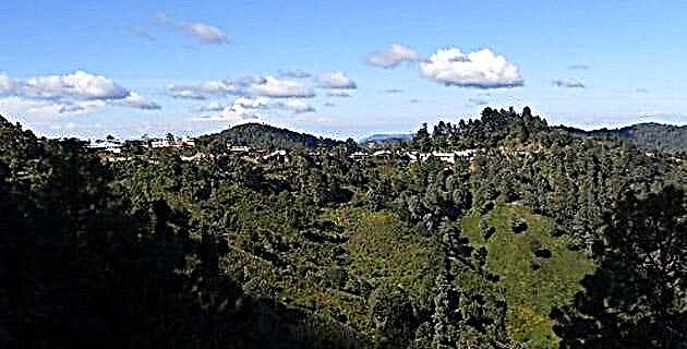
The Sierra de Filo de Caballo is located in the Sierra Madre del Sur, northwest of the city of Chilpancingo, in the state of Guerrero. In it there are three large plateaus of calcareous mass (a portion of soil made up of limestone) ideal for the formation of caves, cellars and drains, which are a challenge for cavers who wish to find new cavities.
The Sierra de Filo de Caballo is located in the Sierra Madre del Sur, northwest of the city of Chilpancingo, in the state of Guerrero. In it there are three large plateaus of calcareous mass (a portion of soil made up of limestone) ideal for the formation of caves, cellars and drains, which are a challenge for cavers who wish to find new cavities.
In 1998, when studying the topographic charts and aerial photos of this area, Ramón Espinasa realized that the existence of a large number of sinkholes (depressions in the ground with no apparent outlet and generally conical in shape) and rivers that are suddenly truncated, it would represent good potential to explore. Knowing that no caving group worked in the area, he decided to take a look together with Ruth Diamant and Sergio Nuño.
On the first trip they only traveled a few roads, being able to observe and confirm the large sinkholes in the Filo area.
In the four subsequent trips, with more people and more time available, they were dedicated to prospecting and positioning of holes and cavities. They could not descend too far because the search was carried out in the rainy season. As more cavities were discovered on each of the exploration trips, spirits grew.
One of the most important finds was made by Ramón in topographic chart no. INEGI's E1 4C27, in mid-2000, when he saw a depression and a river running into it, it could only be a cave and, better still, everything seemed to indicate that the exit should be a kilometer away, with an approximate differential of 300 meters in height, once again the river resurfaces.
In August an outing was organized with Ruth and Gustavo Vela. During the exploration they found many entrances to caves and cellars. They were also directed by means of a GPS (global positioning system via satellite) to the coordinates of the great depression that the map indicated in the final part of the southern plateau. After a long walk they were fascinated to see a large fossil entrance to a cave. They carefully walked down the steep incline that the entrance presented. Upon reaching the base they found a large room. Inside it, they walked about 100 meters until they found the river that flowed between some stones and, on the opposite side, they realized that a large tunnel followed.
With these preliminary results, they began the countdown of the days until the end of the rainy season. It took until the beginning of the eleventh month to figure out the depth and distance of this great unexplored cave and whether or not it had an exit at its other end.
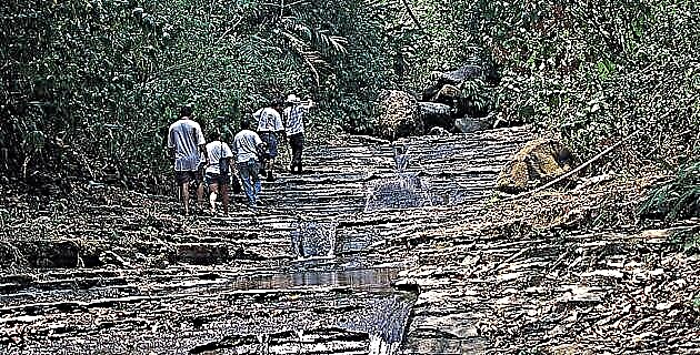
On November 1, 2000, after an eight hour journey from Mexico City to the cave, a team of 10 spelunkers arrived with all the spirits they needed to start exploring and surveying.
They set up the base camp in the middle of a thick forest. A large bonfire warmed the looks, the thoughts and the conversations of what awaited them the next day.
In the morning the teams were organized. The one with Humberto Tachiquin (Tachi), Víctor Chávez and Erick Minero stayed to take care of the camp, enjoying a sunny day. The working groups decided to divide into two to carry out a simultaneous topography (that is, one group would start surveying an area, and the other would go ahead a certain distance so that when the first one reached and passed it, it would leave space, making it faster the job). After an hour of walking they reached the mouth of the cave. The group of Ramón, Ruth and Arturo Robles began with the measurements of the great hall, finding a skylight in which the rays of the sun beautifully entered and that would lead to an upper entrance; they also saw some wall collapses and roof collapses. Meanwhile, the group of Gustavo, Jesús Reyes, Sergio and Diana Delfín started with the entrance ramp and then continued straight ahead, dedicating themselves to the topography of the tunnel that followed the first room.
With an average incline of 18 degrees and dimensions of 20 meters high by 15 wide, the tunnel continued with some de-escalation. The flow of cold water followed them step by step, crossing them sometimes.
Little by little the air current increased until the seven cavers reached the first shot with a waterfall. They saw that next to it there was a fossil branch where it would be easier to go down without getting wet. At 22 meters deep, the shot was once again joined to the river gallery.
They continued to survey until they reached a pool eight meters long. In this one, the level of cold water reached up to their necks, so most of them decided to put on the wetsuit, except Jesús and Gustavo, who thought it would be better to remove their clothes by putting them on their heads when crossing the pool and thus continue dry the exploration. Which worked very well for them.
The next nine-meter shot they found was armed by another fossil branch, saving the waterfall and a pool. That day they decided not to go down any further due to the physical effort they had made, so they prepared to return to the camp to continue the next day.
Two groups left that morning. In the first one were Gustavo, Diana and Jesús, who began with the measurements after the second shot. The cave continued with a great corridor of great dimensions, with a lot of water and some fossil galleries with stalactites and stalagmites surprisingly deformed by the passage of air. Meanwhile, the second group, made up of Tachi, Víctor and Erick, went ahead of the first group, they found some de-escalation with water, more fossil rooms, cavern pearls and the third shot with four meters high, which reached another pool. Some decided to jump it and others to rappel to get to the water and swim out.
About seven hours after starting that day's journey, the six spelunkers saw daylight in the distance. That meant that Ramón was correct in predicting geologically that it would be a cave with a second exit at the other end.
Diana's team made it to the fourth shot that was seven meters high. This fall also reached a pool and the same thing happened: some jumped and others went down the rope. The excitement overwhelmed everyone, as there was a great desire to finish the topography and reach the light of day.
To get out, the first team had to put the rope on the fifth and final shot and swim. Tachi's team climbed a fossil branch to survey it and take the ancient exit of the cave, through which the water flowed thousands of years ago because the lower part had not been eroded.
After the work was finished, they looked for the difficult road to the camp (difficult because they could find it after an hour) and two hours later they talked with their colleagues about the final results.
They were the first cavers to make the crossing of the “Puente de Dios Cave-Resurgencia Cueva de la Mano”. The name was given to them by the locals long ago.
On the fourth day of work, the team of Ramón, Ruth and Sergio left, followed by Tachi, Jesús and Arturo to finish surveying some pending branches and to remove the rope. This last trip was made from the bottom up in order to make the tour of the cave in reverse.
Finally, the cave was 237.6 meters deep and 2,785.6 meters long. And although it was not very deep, the marble corridors beautifully polished by the water, the curious formations and the dynamism of the water give way to one of the most beautiful caves in the state of Guerrero, whose journey is unforgettable.
On the last night, satisfied with the achievement achieved by the SMES group (Sociedad Mexicana de Exploraciones Subterráneas) and having the assurance that they would continue exploring this interesting area, they planned the return to Mexico City.
IF YOU GO HORSE EDGE
Leaving the city of Cuernavaca, take federal highway no. 95 heading for the coast; it will pass through several towns, among them Iguala; then it will travel 71 km until the deviation, in Milpillas, to a secondary road. After traveling about 60 km you will reach Filo de Caballo, where the Puente de Dios Cave is located, located on the edge of the Guerrero State Natural Park.
Source: Unknown Mexico No. 291
Sierra Madre del Sur