When we look for the Abra-Tanchipa region on a map, we find a point between the cities of Valles and Tamuín, east of the state of San Luis Potosí.
So, we plan to visit one of the youngest reserves in the country. In the past it was the seat of Huastec settlers and today it remains free of human settlements, although in its area of influence there are fifteen ejidos whose inhabitants are dedicated to cattle ranching and rainfed agriculture, with crops of corn, beans, safflower, sorghum, soybeans and sugar cane.
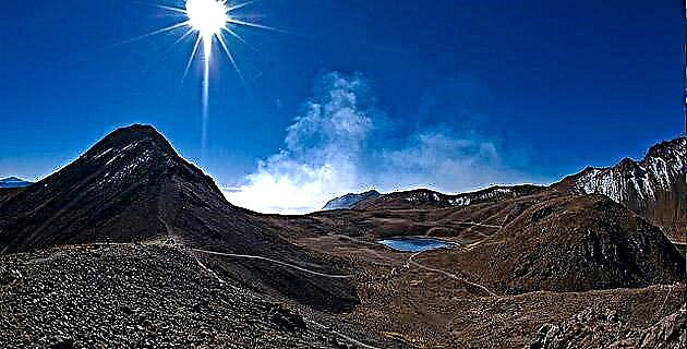
It is one of the least extensive biosphere reserves, with an area of 21,464 hectares of communal, national and private lands. Almost 80 percent of the land constitutes the core area, destined for scientific research activities. It occupies the region known as Sierra Tanchipa, with unique ecosystems and biotic and abiotic elements that form one of the redoubts of flora and fauna, with Neotropical characteristics, further north of the country.
Besides being part of the Sierra Madre Oriental, it constitutes an important factor for regional climatic conditions, because it acts as a meteorological barrier between the coastal plain of the Gulf and the altiplano. Here, the rising wet sea winds cool as they touch land, and the moisture condenses and produces abundant rainfall.
The climate is hot most of the year. The temperature varies little, and averages 24.5 ° C per month. The rains are frequent in summer, and the annual average rainfall of 1,070 mm represents an important source of recharge of the water table for the area of influence and the springs of the region. There are six permanent bodies of water, such as La Lajilla, Los Venados, Del Mante dams, and Los Pato lagoon; several temporary bodies of water, two rivers and a stream, which maintain the water cycle of the area, stabilize the vegetation and favor the two hydrological systems: the Pánuco river basin, Valles and Tamuín (Choy), and the river basin Guayalejo, constituent of the Tantoán river.
TROPICAL BIODIVERSITY AND ARCHAEOLOGICAL VESTIGES
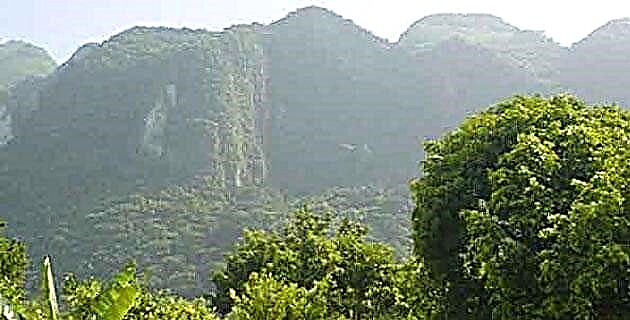
The preliminary floristic inventory records 300 species among vascular plants and freshwater algae; with endangered species, such as the Brahea dulcis palm, the Chamaedorea radicalis palm, the Encyclia cochleata orchid, the Dioon eduley chamal and the Beaucarnea inermis soyate which is abundant. The trees reach heights of 20 m and form the semi-perennial medium forest, not very abundant, and present only as patches on high ground, where it mixes with the sub-deciduous forest, more disturbed by clearings and pastures, because it occupies flat floodable lands to the east of the reservation.
Another type of vegetation is the low forest that partially loses its foliage at some time of the year; it occupies poor calcareous soils and is mixed with the medium forest, which is the best represented between 300 and 700 m asl. In the great plains of the northwest, the original flora has been replaced by the secondary vegetation and palm groves of Sabal mexicana, derived from the lower jungle and induced by frequent fires.
In the western plains, thorny shrubby strata and not very diverse herbaceous dominate. A unique plant stronghold is the tropical holm oak Quercus oleoides, which corresponds to an isolated flora in small lower portions of the sierra. It is distributed in the coastal plain of the Gulf of Mexico, from the tropical forest of the Huasteca Potosina to Chiapas. These are fossil forests that constitute remnants of vegetation, once dominant associated with temperate and cold climates from the times of the last ice age (between 80,000 and 18,000 BC).
The decrease in temperature during the glaciation led to the presence of these holm oaks in extensive plains of the Gulf coast, which are a sample of fragile ecosystems now quite disturbed and survivors of colder times.
Regarding the local fauna, the records include more than 50 species of mammals, among them felines threatened with extinction, such as the jaguar Panthera onca, the marlin Felis wiedii, the ocelot Felis pardalis, and the puma Felis concolor. There are fauna of hunting interest, such as the Tayassu tajacu wild boar, the white-tailed deer Odocoileus virginianus and the rabbit Sylvilagus floridanus, among others. The avifauna adds more than a hundred resident and migratory species, of which protected birds stand out such as the “red-fronted” parrot Amazona autumnalis, the calandrias Icterus gulariseI. cucullatus, and the chincho Mimus polyglottos. Among reptiles and amphibians, around 30 species have been identified: the Boa constrictor snake, considered in danger of extinction, represents the largest reptile. As for the invertebrates, there are more than 100 families with hundreds of almost unknown species.
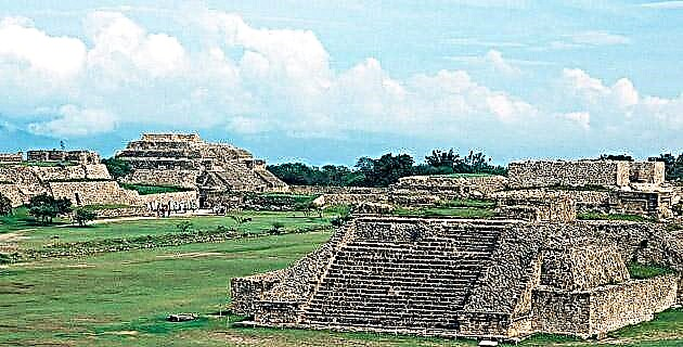
The reserve has relevance in the cultural and anthropological aspects, for having been a wide area of human settlements of the Huasteca culture. 17 archaeological sites have been identified, such as Cerro Alto, Vista Hermosa, Tampacuala, El Peñón Tanchipa and, the most prominent, La Hondurada, an important ceremonial center. The reserve has half a dozen little-explored caves, among which Corinto stands out, due to its size, and Tanchipa, the remaining ones are El Ciruelo and Los Monos, as well as countless cavities with petroglyphs or carved stones.
THE TANCHIPA CAVE, INTERESTING SITE WITH HIDDEN SECRETS
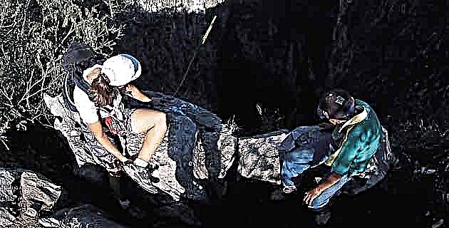
The plan to visit the reserve included several routes, but the most interesting, without a doubt, was to get to the Tanchipa cave. The group was formed with Pedro Medellín, Gilberto Torres, Germán Zamora, the guide and myself. We equip ourselves with a compass, food, a machete, and at least two liters of water each, because in this area it is scarce.
We left Ciudad Valles very early, to continue on the highway to Ciudad Mante, Tamaulipas. To the right, behind the wide plains of the small mountain range that make up the reserve and, at the height of the Laguna del Mante ranch, at kilometer 37, a sign indicates: “Puente del Tigre”. We slowed down because 300 m later, on the right, the deviation of six kilometers of dirt road begins that leads to the “Las Yeguas” property where we left the four-wheel drive vehicle. From this point on, we find a gap covered with herbaceous plants, due to disuse and, on both sides, bushes and thorny acacias Gavia sp, which when blooming embellish the path, called “Paso de las Gavias”. For a long distance we were accompanied by secondary vegetation, derived from ancient pastures and dotted with Mexican royal palm Sabal, up to where the slope required more effort to climb. There we felt that the environment changed; the vegetation becomes more dense and the tall trees of chaca Bursera simarubay red cedar Cedrela adorata, reach 20 m in height.
We ascended a path surrounded by plants that we have seen as ornaments in many parts of the country, such as mocoque Pseudobombax ellipticum, cacalosúchilPlumeria rubra, palmilla Chamaedorea radicalis, pitaYucca treculeana, chamalDioon edule, and soyateBeaucarnea inermis. They are species that abound here in their original environment, where they take root between cracks and huge carbonated rocks to take advantage of the scarce soil. At every step we avoid lianas, thorns and large royates that, with their wide bases, resemble elephant legs and dominate almost the entire mountain range. In the midst of the vegetation, about eight meters high, other species attract attention, such as the hard "rajador" tree, the "palo de leche" (used to enciela fish), the chaca, the tepeguaje and the fig tree, with trunks covered with orchids, bromeliads and ferns. Under the foliage, smaller plants such as guapilla, nopal, jacube, chamal and palmilla fill the spaces. Among the flora observed are 50 species used in traditional medicine, construction, decoration and food.
The walk tired us because for three hours we traveled the journey of almost 10 km to reach the top of the mountain range, from where we appreciated a large part of the reserve. We no longer continue further on, but a few kilometers, through the same gap, we reach the vestigial vegetation of tropical oak and little-known places.
We enter the Tanchipa cave, whose absolute darkness and cool climate contrast with the outside environment. At the entrance, only a dim light bathes and delineates its outline, formed by walls of calcite crystals and covered by greenish layers of moss. The cavity is about 50 m wide and more than 30 m high in the curved vault, where hundreds of bats hang nestled in gaps between the stalactites and, in the dusty bottom, a tunnel goes more than a hundred meters deep in the dark cracks.
The cave is not just darkness. The most interesting was found on the bottom floor, where the remains of an adult man rest, as can be seen from the bones piled up in a corner. Nearby, a rectangular hole stands out, the product of a looted tomb that only preserves the elongated river stones brought from distant lands to cover the remains of the strange character. Some local residents tell us that, from this cave, skeletons with seven giant skulls, between 30 and 40 cm, were extracted with a perforation in the center of their upper portion.
The cave, located at the top of the mountain range, is part of a depression of more than 50 m high, with the bottom covered with rich vegetation of platanillo, avocado, fig tree; herbaceous and lianas different from those of the outside environment. To the south of this site the Corinth cave is much larger and more impressive looking and holds secrets hidden within its vast interior. At lunchtime we take advantage of one of the cavities at ground level, where it is also possible to spend the night or take shelter from the rain.
The return is faster, and although it is a rather tiring journey, we now know that this mountain range, which was declared a Biosphere Reserve on June 6, 1994, has great iotic importance, various almost unknown archaeological remains, well-preserved plant communities, and constitutes a strategic natural refuge for regional fauna.