Towards the central-western part of the Copper Canyon, from the high plateaus, two prolonged streams emerge, those of Oteros and Chinipas, forming two of the great ravines of the region, which bear the names of their respective rivers.
Further north of Chinipas, these ravines join and many kilometers below, already within the state of Sinaloa, the Chinipas river joins the Fort, which by then carries the waters that come from the impressive Sinforosa, Urique, Cobre and Batopylae.
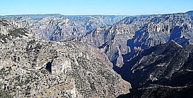
The beautiful Barranca Oteros-Chinipas reaches its maximum depth, 1,600 meters in its portion of the Chinipas River, although part of the current reaches 1,520 meters deep. This canyon is one of the most unknown and probably has not been covered in its most abrupt parts.
How to get
This ravine, one of the longest in the mountains, has four access zones: One is through the region between Creel and Divisadero; the second is for the mining town of Maguarichi; the third, and the one that is considered its main entrance, is through Uruachi. One last road, difficult due to its poor conditions, is that of Chinipas.
Maguarichi, Uruachi and Chinipas services are modest; its hotels and restaurants are simple, electricity and telephone services have limited hours, and its roads are unpaved.
From the city of Chihuahua, Maguarichi is 294 km away, along the Cuauhtémoc-La Junta-San Juanito highway; Uruachi is located 331 km away and is reached by Basaseachi, from where it takes two hours along a dirt road in good condition; and Chinipas is 439 km away and from Divisadero, as far as the highway reaches, it is like seven hours of bad dirt.
caves
One of the most interesting is the Cave of the Mummies, in the Otachique valley near Uruachi. In this cavity there are remains of three mummies, possibly of Tarahumara origin, as well as numerous vestiges associated with this culture. Within the same valley is the Cueva del Rincón del Oso, with various archaeological pieces such as metates and old corn cobs.
In Uruachi, but in the Las Estrellas valley, there is the series of cavities of the Peña del Pie del Gigante and the Cueva de la Ciénega del Rincón, which shelters some adobe houses of the Paquimé style.
Viewpoints
The best viewpoints are those of the Choruybo and Oteros ravines, near the town of Uruachi. From the Cerro Colorado you can see the entire Uruachi valley and the Barranca de Oteros, covering a view of more than 100 kilometers around from where you can see the state of Sonora.
In Maguarichi
you have a perfect view of the upper portion of the Barranca de Oteros. And in the Chinipas viewpoint you can see its valley surrounded by rocky peaks, and the town with its old mission by the river.
Stone formations
Los Altares, in the valley of Otachique, are a series of rocks that give the sensation of being a labyrinth, and the aforementioned Pie del Gigante, in the valley of Las Estrellas, a huge rock that stands out for the shape that gave it its name .
At the foot of Cerro Colorado, the one with infinite viewpoints, there are unique greenish rocks with a height of about 70 to 80 meters that stand out in the landscape. These formations are known as the Cantiles del Arroyo de la Ciénega, and they are visible from Uruachi.
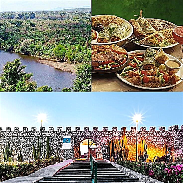
Streams and rivers At the bottom of the ravine, descending through Uruachi, you reach the Oteros River, near La Finca, a small community on the banks of the stream, there is a hanging bridge that is worth visiting. In the town we will find its old adobe houses and its orchards, full of fruit trees such as mangoes, avocados, sugar cane (they even have a mill), orange trees, lemons, papayas, etc. In some, the limes permeate the environment with their scent.
The house that is properly called La Finca, is a huge construction from the beginning of the century, very well preserved. It has a large garden, a wonderful ditch that crosses the side of a hill among the dense tropical vegetation. In the Oteros river there is fishing for at least four species of fresh water such as matalote and catfish.
Waterfalls and hot springs The most important waterfalls in this area are those of Rocoroybo, made up of three waterfalls, the largest with a drop of about 100 meters. A day of walking from Uruachi is required to reach it. Also by the direction of La Finca, near Uruachi, are the Mirasoles waterfalls with 10 meters of fall, the Salto del Jeco with 30 meters, and one of 50 meters that has no name.
The Lumbren Stone spring in the Maguarichi community is reputed to have healing properties.
Mission routes
As already mentioned, the Chinipas region was the gateway to the evangelization and colonization of the Tarahumara. In its surroundings there are missions and vestiges that represent the first traces of western culture in the Copper Canyon. Among them are: Santa Inés de Chinipas (Chínipas, 1626), Santa Teresa de Guazapares (Guazapares, 1626), Santa María Magdalena de Témoris (Témoris, 1677), Nuestra Señora de Aranzazú de Cajurichi (Cajurichi, 1688) and Jicamórachi ( century XVIII).
Mining towns
This region has some of the oldest, most beautiful and best preserved mining towns that can be found in our country. Such is the case of Chinipas that it began as a missionary community, but since the 18th century it acquired the appearance of a mining town, when several minerals were discovered in its vicinity. Its adobe architecture is from the last century, and is very well preserved. Two old locomotives dominate its two squares, which, brought by the English miners in parts and on the back of a mule, were armed there. You can also admire an aqueduct of nineteenth-century construction that is no longer used and that is in perfect condition.
Close to Chinipas is the old Palmarejo mineral, which dates from 1818 and whose mines still produce. Here stands out its beautiful temple dedicated to Our Lady of the Refuge.
The town of Maguarichi was founded in 1749, when its gold mines were found. Now, without being depopulated, it looks like a semi-ghost town.
Its temple of Santa Bárbara, from the end of the 18th century, draws attention; the old hospital built in the early years of the 20th century; the Casa Banda, the pool table and the Conasupo store, which are buildings from the 19th century, with two floors and in good condition.
In Uruachi, a mining town that originated in 1736, there are many large adobe constructions with two floors and two walls, and wooden railings.
Its inhabitants usually paint them in bright and contrasting colors. From afar you can see the tin roofs of their houses, a characteristic feature of almost all places in the mountains.
Tarahumara festivals Within all the indigenous groups that inhabited the Barranca Oteros-Chinipas region, we can mention chínipas, témoris, guazapares, varohíos, tubares and Tarahumara.
With the passage of time, only the latter, that is, the Tarahumara and the Varohíos, have survived, although they have been relegated to very few communities. Of these groups, the one that best preserves its festivals and traditions, such as the celebration of Holy Week, is the community of Jicamórachi, on the way to Uruachi.
Walking tours
Of the possible excursions we suggest those that take place from the Otachique valley to Uruachi, ascending in a few hours to the summit of Cerro Colorado and the one that goes from La Finca to the Rocoroybo Waterfalls, a walk that can be done in one to two days, but that will be well rewarded at the sight of the waterfalls.
Of enormous scenic interest is the walk between Maguarichi and Uruachi, following the course of the Oteros River through the bottom of the canyon.