With all our mountain equipment ready, ropes, crampons, ice axes, ice screws, well wrapped up and with well-shod boots, we headed to Iztaccíhuatl to enjoy an exciting weekend in the mountains.
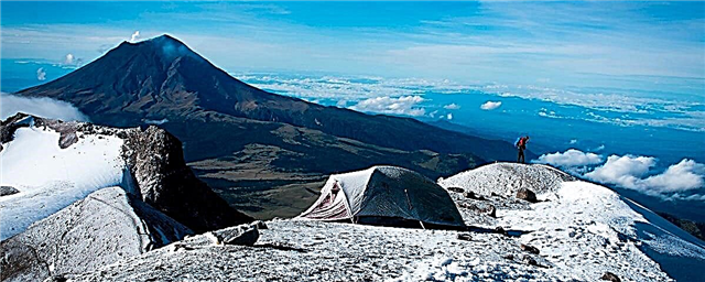
Currently Popocatépetl cannot be ascended due to its continuous volcanic activity, so those of us who like to practice mountaineering, we make our excursions in Iztaccíhuatl, where the third highest peak in Mexico is located, located in "el breast" at 5,230 m high.
The most important peaks of Iztaccíhuatl are the feet, knees, belly, chest and head, which can be accessed by different routes, some more difficult than others. Among the toughest is the Via del Centinela, one of the longest rock climbing routes in Mexico. Other routes of high degree of difficulty are the unscalable ones, located in the hair of the Iztaccíhuatl and where Mexican mountaineers carry out our ice practices. One of them is known as the Oñate Ramp, which takes you directly to the chest and into the Ayoloco glacier, located in the Iztaccíhuatl belly.
The classic
If you are just starting out in the high mountains, we recommend you to ascend this one, which starts in La Joya and passes through several of its peaks, feet, knees, shins, belly and chest. It is a very long walk, about ten hours.
It is recommended to start in the early morning to enjoy the sunrise that paints the fumaroles of Popocatepetl with fire. It is necessary to be accompanied by a guide, carry crampons, ice ax and rope to be able to cross the glaciers of the belly and chest.
Head
Here the access is different, first you have to reach the town of San Rafael, and from there continue along the dirt road to Llano Grande, where the walk begins between the zacatales until reaching an immense ramp of sand and rocks known as “El Tumbaburros ”, where it seems that you take one step and go back two until you reach the hill that separates the massif from the head and the chest. The route is steep as you have to climb a long corridor of snow until you reach the summit at 5,146 meters.
The Ayoloco glacier
After several ascents and training, you can face this which is one of the most difficult routes. The starting point of this route is La Joya, in the Paso de Cortés, and this glacier takes you directly to the summit of the belly. In 1850 the first attempts were made to ascend this route, but they failed due to lack of equipment to overcome the ice walls. In November 1889, H. Remsen Whitehouse and Baron Von Zedwitz managed to climb the glacier using a rustic ax with which they dug steps and what would be their surprise when they found a bottle with a message inside left by the Swiss James de Salis, who had reached the summit five days before them. The ice of the Mexican mountains is difficult to climb, it cracks very easily and at the same time it is very hard, you have to hit it again and again to fit the ice axes and crampons.
The Oñate ramp
This route is longer than the previous ones, so it takes two days. It departs from La Joya, and it is recommended to camp at the base of the Ayoloco glacier to face the gigantic Oñate ramp the next day, which runs along the northwestern glacier directly to the summit of the chest. This route is named in honor of Juan José Oñate, who along with his fellow climbers Bertha Monroy, Enriqueta Magaña, Vicente Pereda and Zenón Martínez died in a tragic accident on that route in 1974.
If the ice is in very good condition, you can ascend at a good pace up the icy 60 and 70 degree incline ramp, enjoying a spectacular view of the head. After several strenuous hours, you can reach the highest peak of Iztaccíhuatl, the chest. We invite you to visit our mountains and National Parks with respect. If we want more snow-capped volcanoes every year, we have to reforest them so that there is more humidity, more water, more snow and more beauty. Let us not anger the gods who dwell on its icy peaks.
Photographer specialized in adventure sports. He has worked for MD for over 10 years!