The great diversity of rivers, basins and lagoons of enormous proportions, as well as mangroves, territorial bars, islands and reefs that extend along the entire coast of Veracruz make up, like the strings of a Jarana Jarocha, Huasteca or the region of Los Tuxtlas, the most complete harmony of the gifts of nature.
To be more explicit, it represents one of the territories with the greatest wealth in fruits and animals of almost all species, from dolphins and turtles to migratory birds, which on their route southward take the obligatory passage by some point of the Veracruz coastline. These qualities, together with the high mountain ecosystems that form the Sierra Madre Oriental, have given this region of the continent the recognized fame of the “horn of plenty”.
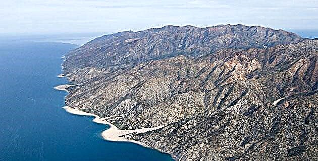
As incredible as it may seem, it is a difficult land to conquer, hurricanes penetrate from the Caribbean and the north surprises us on a peaceful afternoon enjoying the incandescent rays of the sun that flirt on the sand, where the wind moves from north to south through its extended plains, carrying anecdotes of pirates and troubadours that remind us of the mysteries of the sea. The main hydrographic basins marked from the beginning the territories of the ancient cultures and based on this we will undertake a long journey from south to north.
Olmec route We will start with the Olmec route that runs from the Coatzacoalcos river slope to the Papaloapan river basin. Between the two basins is located the region of Los Tuxtlas, of volcanic origin and the last stronghold of high evergreen forest in the state of Veracruz.
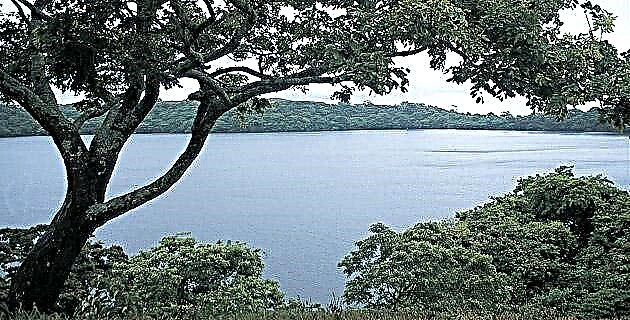
The only two mountain ranges closest to the Gulf Coast are found here; the San Martín volcano and the Santa Martha mountain range. At the foot of both, the coastal lagoon of Sontecomapan rises, which is fed by numerous rivers and mineral water springs, forming an extensive network of mangrove channels in the direction of the sea. This area, which was isolated for a long time, is now connected by a paved road that is located about 20 minutes from the town of Catemaco.
In the small town of Sontecomapan, located on the shores of the immense lagoon, there are two routes that are well worth taking the time to enjoy. The first is by boat from the jetty, crossing a channel, the thick mangrove vegetation opens up to give way to the lagoon until you find a small portion of dunes that form the bar that bears the same name.
The Sontecomapan bar is an excellent place to eat, but there are no more services and one day is enough to enjoy its corners, however for adventurers it would take more time to reach the reefs of "the pearl of the gulf", located south of the bar and whose access is only by sea.
An easily accessible dirt road begins from the riverside town of Sontecomapan towards Monte Pío. Costing for half an hour, we leave behind the open beach of Jicacal, a viewpoint and the only hotel along the way overlooking a small beach known as Playa Escondida.
On the dirt road, we find ourselves on the slopes of the San Martín Tuxtla volcano, a small portion of jungle that is a UNAM reserve, which protects the great wealth of flora and fauna native to the region. Among many other species, the real toucans, the howler or sarahuato monkey, reptiles and an infinity of insects stand out. And just 15 minutes on the same road we reach the beach of Monte Pío, a beautiful corner where rivers, jungles and beaches meet; horseback riding, modest hotel and restaurant services; landscape of exuberant vegetation, mysterious legends and paths that lead us to isolated towns and legendary waterfalls. Its beach extends for several kilometers to a rock formation called Roca Partida, the northernmost point of the Tuxtlas region that, for better or for worse, there is no coastal road to it, therefore, one way to get there would be on horseback. or walking along the coast, or by boat, which can be rented near the mouth of the river.
Between the river and the sea a narrow bar is formed very accessible for camping and swimming on both sides, venturing upriver towards the slopes of the volcano and discovering its different waterfalls and excellent views.
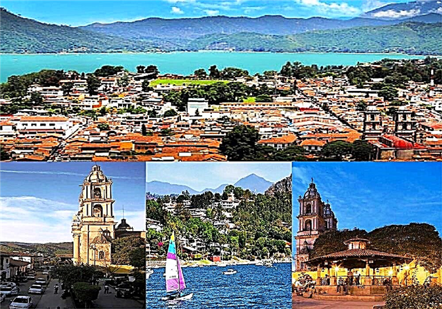
Route of the Son To continue north, it is necessary to return to Catemaco and go down through San Andrés Tuxtla and Santiago. From this point begins the extensive plain of the Papaloapan river basin, a clear geographical and cultural division where Tlacotalpan, Alvarado and the port of Veracruz meet. It is a cultural region defined by its excellent gastronomy and its music, that is why we will call it “the route of the son”.
After passing the sugar cane zone of Angel R. Cabada and Lerdo de Tejada, the deviation that leads along the banks of the Papaloapan River to Tuxtepec appears, and the first riverside town known as "the jewel of Papaloapan" is Tlacotalpan. This name has been disputed for years by the port of Alvarado and this small and romantic town. However, the peace and architectural beauty of Tlacotalpan is not evoked by any other population in the basin; It is a very touristy place and therefore has very good services for travelers. Walking through its streets is a visual pleasure and is an ideal place to rest; On the other hand, for the fun and good seafood, it is advisable to return by the same road to the port of Alvarado, where there are innumerable places to savor a good shrimp cocktail or a delicious rice a la tumbada.Our next point towards the city of Veracruz, It is the Mandinga lagoon, from Boca del Río, in the direction of the Antón Lizardo point. This lagoon is the northern end of a lagoon complex made up of six elements: Laguna Larga, Mandinga Grande, Mandinga Chica, and the El Conchal, Horconos and Mandinga estuaries that flow into the sea.
The town of Mandinga has some good restaurants and pleasant boat rides that cross from the Chica lagoon to the Grande lagoon, from where you can enjoy the sunset on the many islets, the bird refuges.
It has camping areas on the shores of the lagoon, and the hotel zone is located from El Conchal to Boca del Río.
The Sotavento plain has remained to the south of Boca del Río, the most important municipality in the state of Veracruz for its hotel and restaurant services, as well as the famous Mocambo beach and the increasing modernization of its avenues that lead us, along from the coast, to the port area of the legendary city of Veracruz.
Route of the pirates: The next point of interest of our trip, along the coasts of Veracruz is undoubtedly the area recently decreed as a Reef Reserve in the center of Veracruz.
Formed mainly by the Isla de Sacrificios, the island of Enmedio, the Anegadilla de Afuera reef, the Anegadilla de Adentro reef, the Verde Island and Cancuncito, among others, it is one of the most important reef reserves in the Gulf of Mexico. This route could well be called the pirate route, since historical and shipwrecked battles took place in its waters in colonial times and even later. Its shallow reefs are a paradise for diving enthusiasts, especially Enmedio Island, located off the coast of Antón Lizardo, where you can camp without so many restrictions, but yes, taking everything you need.
Totonac route: After drawing mermaids and enjoying isolation, we return to the mainland to enter the area where the Totonac civilization flourished. This route goes from La Antigua to the lands bathed by the Tuxpan river and the Cazones bar; natural and geographical limit between the Totonacapan region and the Huasteca Veracruzana.
Between Chachalacas and La Villa Rica, countless dunes extend northward that separate the salty sea from small lagoons; Some of them have no outlet and remain still, preserving their fresh water nature, such is the case of the El Farallón lagoon, known as a camp and later division of the workers of the Laguna Verde nuclear power plant, in the vicinity of La Villa Rica from Veracruz.
At this geographical point two physiographic provinces are divided and there is a narrow third-party road that climbs a rock known as the Cerro de los Metates and at the foot is the most beautiful pre-Hispanic cemetery in the Totonac world: Quiahuistlan, where the world of the dead rests. observing the life and majestic view of the Villa Rica beach, the Farallón island and everything that today is the Laguna Verde region.
Along this route there are many roadside restaurants where you can savor a delicious shrimp chipachole and the classic dry chili sauce with chips and mayonnaise. In this area, paragliding is practiced, a type of parachute that is carried away by the winds, gliding, until landing in the dunes.
A few kilometers from the Farallón, the beach of La Villa Rica is located, where it is worth spending a few days and exploring its surroundings: La Piedra, El Turrón, El Morro, Los Muñecos, Punta Delgada, among other reefs and cliffs. If we continue north, we pass through Palma Sola, a modest fishing village that has the most essential services for travelers.
By road no. 180 towards Poza Rica, we find another interesting region with an excellent culinary tradition that begins near the Nautla River, on the bank of which is a town of French origin called San Rafael, ideal for tasting its cheeses and exotic dishes. The lighthouse, a few kilometers north of Nautla, marks two roads: the one that leads to the Sierra de Misantla and the coastal one that continues along the famous Costa Smeralda.
Palm trees and acamayas, seafood and open sea are the characteristics of the last coastal plain from Nautla to the Tecolutla River, since after crossing the estuary, the road deviates from the coast to continue along the hills that lead to the city of Poza Rica, an obligatory point for commercial transactions, mechanical workshops, etc.
Huasteca route: The Huasteca coastal route is found between two important rivers, the Tuxpan river to the south end and the Pánuco river to the north. The port of Tuxpan is well connected and is about 30 minutes from the city of Poza Rica. It has all the services and it is recommended to visit the Historical Museum of the Mexico-Cuba Friendship (located in Santiago de Peña) and the Archaeological Museum, located in the center of the city, with more than 250 pieces belonging to the Huasteca culture.
From this high altitude port, a narrow coastal road emerges towards the riverside town of Tamiahua on the shores of the immense lagoon of the same name. In this scenario, just 40 km from Tuxpan, there are numerous estuaries, bars and channels that make up a salty lagoon of great proportions, with an approximate length of 85 km by 18 km wide, the third largest in the country.
Due to the shallow depth of the lagoon, its waters are ideal for catching shrimp, crabs, clams and oyster farming.
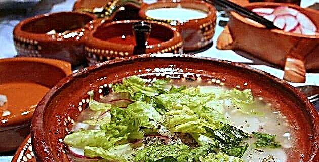
If to all this we add the wonderful seasoning of its cuisine, it is clear to us why Tamiahua is known as the capital of gluttony throughout the northern region of Veracruz; Pepper oysters, huatapes, chipped shrimp, accompanied by delicious pipián enchiladas, are just one part of its great variety.
In this town there are modest hotels and a wide variety of restaurants and from its jetty you can plan a good boat trip through the bars and estuaries such as the Barra de Corazones that leads to the sea or to the island of La Pajarera, that of Idolos or the island of Toro, in the latter a special marine permit is required to access it.
There are other islands even more interesting, but their expedition requires more than a day and with a sufficient supply of provisions. For example, Isla de Lobos, a diving paradise, as it arises from a chain of living coral reefs from the subsoil of Cabo Rojo. Here it is possible to camp only asking for permission and to get there it is necessary to rent a boat with a good motor, with an approximate time of an hour and a half from Tamiahua.
This region is one of the least explored areas of the state and with the greatest marine wealth, but to visit it, as in most of the coasts of Veracruz, the months of March to August are recommended, since the north and the cold wind of the months winter could cause a tragedy impossible to describe.
The inhabitants of Veracruz have no choice but to enjoy its humidity, its environment, its food and its landscape. Nor why get bored, if there is danzón at night in the port, in Tlacotalpan fandango, and in Pánuco, Naranjos and Tuxpan a huapango to rejoice the heart.
Source: Unknown Mexico No. 241