In the Mexican territory there are many volcanoes and mountains. We usually refer to them by the name the Spanish gave them: do you know what the original names of the highest mountains in Mexico were?
NAUHCAMPATÉPETL: THE SQUARE MOUNTAIN
Popularly known as the Perote's Chest, owes this name to a soldier of Hernán Cortés, named Pedro and nicknamed Perote, who was the first Spaniard to climb it. Located in the state of Veracruz, it has a height of 4,282 meters above sea level and is one of the most beautiful mountains in the Sierra Madre Oriental. Its slopes have deep ravines and several secondary basalt cones, whose currents form extensive mantles covered with pines and oaks.
IZTACCIHUATÉPETL (OR IZTACCÍHUATL): THE WHITE WOMAN
It was baptized by the Spanish with the name of Sierra Nevada; it has a height of 5,286 meters above sea level and a length of 7 km, of which 6 are covered by perpetual snow. From north to south it presents three eminences: head (5,146 m), chest (5,280 m) and feet (4,470 m). His training is prior to that of Popocatépetl. It is located on the limits of the states of Mexico and Puebla.

MATLALCUÉYATL (OR MATLALCUEYE): THE ONE WITH THE BLUE SKIRT
Located in the state of Tlaxcala, today we know it by the name of "La Malinche", and in fact it has two elevations that some geographers distinguish as La Malinche, with 4,073 meters above sea level, and "Malintzin", with 4,107.
It is worth remembering that the name "Malinche" was imposed by the natives on Hernán Cortés, while Malintzin was the name of Doña Marina, his famous interpreter.
The ancient Tlaxcala nation considered this mountain as the wife of the rain god.

CITLALTÉPETL, THE CERRO DE LA ESTRELLA
It is the famous Pico de Orizaba, the highest volcano in Mexico, with 5,747 meters above sea level and whose top marks the limits between the states of Puebla and Veracruz. It erupted in 1545, 1559, 1613 and 1687, and since the latter has not shown any signs of activity. Its crater is elliptical and the edge is irregular, with different heights.
The same exploration of which there is evidence was carried out in 1839 by Enrique Galeotti. In 1873, Martin Tritschler reached the very summit and placed the Mexican flag on it.
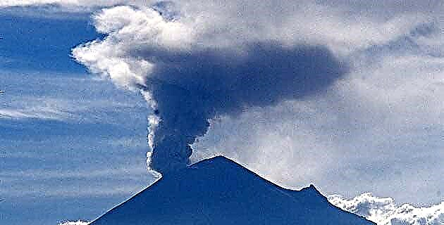
POPOCATÉPETL: THE MOUNT THAT SMOKES
In pre-Hispanic times he was revered as a god and his festival was celebrated in the month of Teotlenco, corresponding to the twelfth twentieth of the year. It is the second highest volcano in the country, with an elevation of 5452 meters above sea level. On its crest there are two peaks: Espinazo del Diablo and Pico Mayor.
The first ascent that can be fixed was that of Diego de Ordaz in 1519, who was sent by Cortés to extract sulfur, which was used in the manufacture of gunpowder.

XINANTÉCATL: THE NAKED LORD
It is the volcano that today we know as Nevado de Toluca; in its crater there are two drinking water lagoons barely separated by a small dune, and they are located at 4,150 meters above sea level. If the height of the volcano were taken from the Pico del Fraile, it is located at 4 558 meters above sea level. At its top there are perpetual snows and its slopes are covered, up to an altitude of 4,100 m, by coniferous and oak forests.

COLIMATÉPETL: CERRO DE COLIMAN
The word "colima" is a corruption of the voice "colliman", of colli, "arm" and man "hand", so that the terms Coliman and Acolman are synonymous, since both mean "place conquered by the Acolhuas". The volcano has a height of 3 960 meters above sea level and divides the states of Jalisco and Colima.
In July 1994 it produced large detonations, which caused alarm among neighboring towns.