The Mexican town of Mapimi has a fascinating story to tell and interesting attractions to show. We present you the complete guide to this Magic Town Duranguense.
1. Where is Mapimi located?
Mapimi is a Mexican town located in the northeastern sector of the state of Durango. It gives its name to the Bolson de Mapimi, the desert region that stretches between the states of Durango, Coahuila and Chihuahua. Mapimi is a place of cultural and historical interest since it was part of the Camino Real de Tierra Adentro that linked Mexico City with Santa Fe, New Mexico, United States, and because of its past in the mining of precious metals, time of the important testimonials remain. Mapimi was declared a Mexican Magic Town to promote the tourist use of its valuable heritage.
2. How is the climate of Mapimi?
The coolest period of Mapimi is the one that goes from November to March, when the monthly average temperature varies between 13 and 17 ° C. The heat begins in May and between this month and September the thermometers mark in the range of 24 to 27 ° C, exceeding 35 ° C in extreme cases. Likewise, in winter frosts of the order of 3 ° C can be reached. Rain is very scarce in Mapimi; They barely fall 269 mm per year, with August and September being the months with the highest probability of rainfall, followed by June, July and October. Between November and April there are no rains.
3. What are the main distances to Mapimi?
The closest major city to Mapimi is Torreón, Coahuila, which is 73 km away. traveling north towards Bermejillo and then west towards the Magic Town on the Mexico 30 highway. The city of Durango is 294 km. from Mapimi heading north on the Mexico 40D highway. Regarding the capitals of the border states with Durango, Mapimi is 330 km away. from Saltillo; Zacatecas is located at 439 km, Chihuahua at 447 km., Culiacán at 745 km. and Tepic 750 km. The distance between Mexico City and Mapimi is 1,055 km, so the most convenient route to go to the Pueblo Mágico from the DF is to take a flight to Torreón and from there finish the tour by land.
4. What is the history of Mapimi?
The Mapima desert was inhabited by the Tobosos and Cocoyomes indigenous people when the conquerors arrived. The Spanish left Cuencamé on an exploratory trip in search of precious minerals and found them in the Sierra de la India, founding the colonial settlement of Mapimi on July 25, 1598. The town was destroyed several times by the Indians until it was consolidated in the hand of its mining wealth, a prosperity that grew until in 1928 the main mine was flooded, cutting off the main economic sustenance.
5. What are the most outstanding attractions?
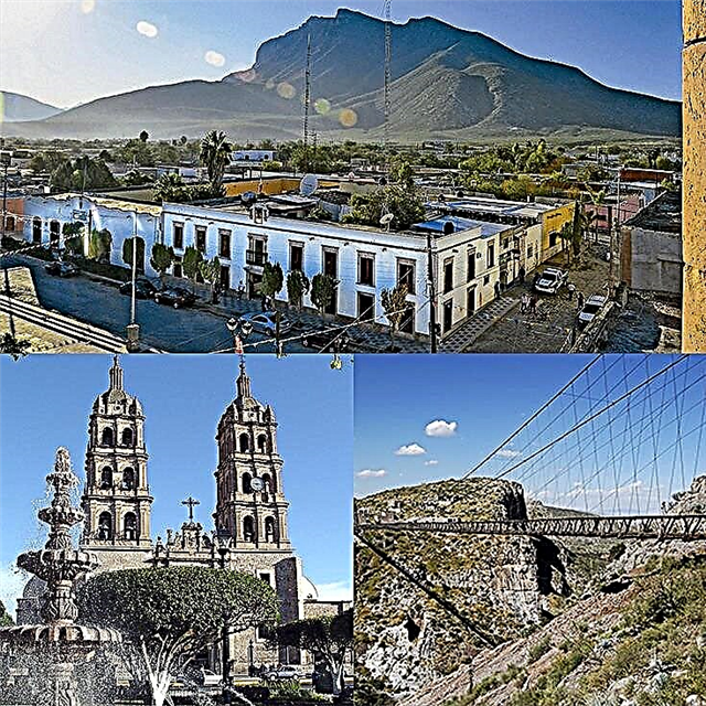
The main attractions of Mapimi are related to the legendary mining past of the area and to historical events that occurred in the town. In the vicinity of Mapimi, the Santa Rita precious metal mine was exploited, leaving as testimonies the mine itself, the ghost town and the La Ojuela suspension bridge, and the beneficiation farm. In the town, two of its mansions were the scene of historical events in the lives of Miguel Hidalgo and Benito Juárez. Other attractions are the temple of Santiago Apóstol, the local pantheon and the Rosario caves.
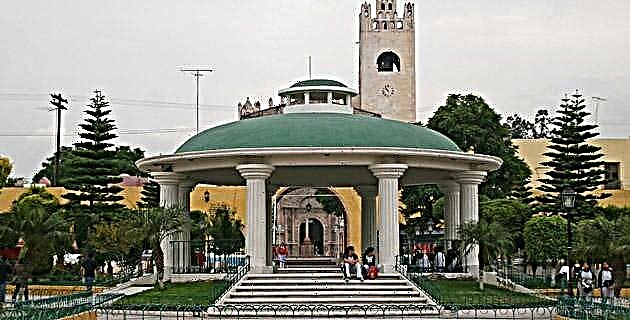
6. What is the Church of Santiago Apóstol like?
This Baroque temple in quarry carved with Mudejar details is located in front of the Plaza de Armas and dates from the 18th century. The main facade is crowned with a sculpture of Santiago Apóstol. The church has a single tower with two floors where the bells are located and is topped by a cross.
7. What is Mapimi's relationship with Miguel Hidalgo?
In front of the Plaza de Mapimi, next to the temple, there is an old house that keeps a sad and historical memory, since Miguel Hidalgo y Costilla was a prisoner for 4 days in a wooden cell, when the Father of the Mexican homeland was being transferred to Chihuahua, where he would be shot on July 30, 1811.
8. What was the town's bond with Benito Juárez?
In another house located in the Plaza de Armas, Benito Juárez spent three nights when he was going north, escaping from the imperial troops that had been pursuing him during the War of the Reform. In the house there is a museum that deals with the history of Mapimi and one of its most valuable pieces is the bed in which Juárez slept. The facade of the house preserves the Duranguense architectural style of the time. Household items, paintings, historical documents and old photographs are also on display.
9. What is the ghost town of La Ojuela like?
26 km. This abandoned mining town is located in Mapimi, where the church remained petrified waiting for the faithful for Sunday mass, while among the ruins of the market the shouts of the vendors offering the best turkeys and tomatoes can still be heard. The town of La Ojuela was next to the Santa Rita mine and of its past prosperity, only the vestiges remained for tourists to appreciate and start their imagination.
10. What is the La Ojuela suspension bridge like?
This marvel of engineering from the time of the Porfiriato was commissioned in 1900 on a 95-meter-deep ravine. It is 318 meters long and was used to transport the mineral extracted from the Santa Rita mine, at the time the richest in the country. It was the object of a restoration, replacing the original wooden towers with other steel ones. From the suspension bridge there are spectacular views of the Zone of Silence.
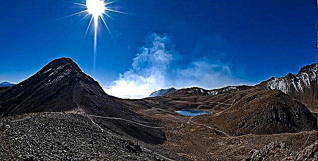
11. What is the Zone of Silence?
This is the name of an area located between the states of Durango, Chihuahua and Coahuila, in which according to an urban legend, some paranormal events occur. There is talk of lost tourists for whom neither the compass nor the GPS works, of problems with radio transmissions, of sightings of unidentified flying objects and even of strange mutations that some species of the flora of the place would suffer. The truth is that it seems that the geography of the area affects the operation of electrical and electronic equipment.
12. What was the Santa Rita mine like and why did it close?
Santa Rita was once the richest mine in Mexico due to its veins of gold, silver and lead, and had 10,000 workers in its heyday. In 1928 the mine was flooded by underground waters that made their way helped by the dynamite that was used in the exploitation. After several years trying to evacuate the water, the mine was finally abandoned, with Mapimi losing its main source of income.
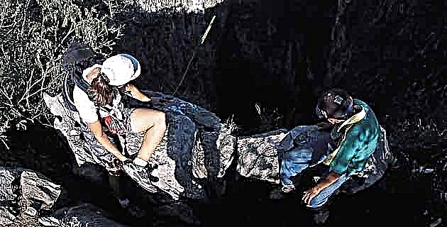
13. Can I visit the mine?
Yes. The mine is currently managed as a tourist interest site by a local cooperative that coordinates the tour, providing a guide and charging a small fee. The tour lasts about an hour and is not recommended for claustrophobic people. The lighting on the tour is with flashlights. One of the interesting things found on the tour is a mule that was mummified as a result of the particular environmental conditions of the place.
14. Are any beneficial properties kept?
The mineral exploited in the mines was taken to the beneficiation farms, which was the place where it was processed to extract the precious metals. The farm workers bought their food in the so-called line stores, where they were discounting the things they bought from their wages, leaving almost always with a debit balance. Of the Hacienda de Beneficio de Mapimi some ruins are preserved, among them the lintel of the door of the ray shop with the initials of the mining company.
15. What else can I do in the mine area?
In front of the Santa Rita mine there are three zip lines that cross the canyon near the La Ojuela suspension bridge. Two of the zip lines are 300 meters long and the other reaches 450 meters. The walks allow you to see the ghost town of La Ojuela and the suspension bridge from above and appreciate the canyon that is almost 100 meters deep. The zip lines are managed by the same cooperative that offers tours of the mine.
16. What's in the Grutas del Rosario?
These caves located 24 km. of Mapimi contain various rock structures, such as stalactites and stalagmites and columns, which have been formed drop by drop, through the centuries, by the runoff of mineral salts dissolved in the water. They have a length of about 600 meters and several levels in which there are natural rooms to admire the formations. They have an artificial lighting system that enhances the capricious appearance of the limestone formations.
17. What is the interest of the Mapimi pantheon?
Although they are not usually included among the most attractive tourist sites, cemeteries can show the evolution of architecture and other facets of life in a place through the splendid mausoleums that the wealthiest families have built. In the Mapimi pantheon there are still samples of the tombs that were erected for the dead of the families of the English and Germans who were part of the engineering and managerial staff of the Peñoles mining company.
18. What is Mapimi's cuisine like?
Durango's culinary tradition is marked by the need to preserve food against inclement weather. For this reason, dried beef, venison and other species, aged cheeses and canned fruits and vegetables are frequently consumed. The dried meat caldillo, the pork with zucchini and the pork rinds with nopales are some of the delicacies that await you at Mapimi. To drink, hold on tight and drink an ashen agave mezcal.
19. Where do I stay at Mapimi?
Mapimi is in the process of consolidating an offer of tourist services that allows increasing the flow of visitors to the Magic Town. Most of the tourists who go to see Mapimi spend the night in Torreón, a city in Coahuila that is only 73 km away. On the Boulevard Independencia de Torreón is the Marriot; the Fiesta Inn Torreón Galerías is located in the Periférico Raúl López Sánchez, as is the City Express Torreón.
Ready to take the dazzling journey into the desert to meet Mapimi? We hope that this guide will be useful for the success of your endeavor.