The Jaguar cenote is something truly impressive. Its maximum depth, underwater, is just over 30 m and there is salty water at the bottom.
The adventure began when you entered the dirt road (sacbe) without announcing yourself. After five kilometers we reached the town of Pacchen. There was a group of Mayans waiting for us. Jaime, the guide who brought us from Playa del Carmen, introduced us to José, a resident of Pacchen, a strong man, smiling and very friendly.
We walked at a fast pace through the jungle; On the way, José explained to us the use of some plants and how he had learned to heal with them. Meanwhile, we arrive at the Jaguar cenote (Balam Kin).
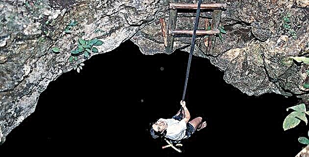
Entering the cenote is something impressive. At first it does not look good, as the gaze has to get used to the darkness, but once it does it is possible to distinguish a huge gallery with deep and crystalline water. It is 13 m of descent to the water. Desiderio, José's brother, received us with a float and once we were free from the rope, he explained: “This place is a sacred place, for our grandparents it was like a temple. This water cures ”. Desiderio introduced us to the magical part of the cenote, but also gave us technical data: he explained that the maximum depth, under water, was just over 30 m and that there was salt water below. The living beings that used the cenote as a home were blind catfish, tiny shrimp, bats, and a bird called to, a relative of the quetzal that nests inside the caves. In fact, when you walk through the jungle and see or hear something, it means that there is a cave nearby.
Desiderio took us to the darkest part of the cenote. "They have to go into the dark to discover the light," he said. "This place is the throat of the jaguar." Actually, you didn't see much, but it felt like we were in a tiny cave. The show began when they turned around to return: the entire cavern could be seen and on the ceiling the projection of light from the entrances that simulated the eyes of a jaguar was clearly appreciated.
Now for the interesting part. How were we going to go up? "We have two ways to go up," Desiderio said. “One is by the rope ladders that come there. To do this they have to hook the rope to their carabiner and we will give them security from above. The other is by means of the Mayan elevator ”(system of pulleys with a block where three men lift the visitors). "The problem is when fat people come," said José when he met us outside.
We walked only about 200 m and came to another cenote, open like a lagoon, which formed a perfect circle. This cenote-lagoon is known by the name of the Cayman cenote, since it is common to see one or more of these animals.
Above the cenote there are two long zip lines approximately 100 m long. After hooking your carabiner to the pulley comes the most exciting part of the journey: jumping off the cliff. It is a very intense feeling, where the best thing you can do is scream. About to reach the other end an elastic rope slows you down and makes you fly almost halfway; it is impossible to fall into the water with alligators. On the other side, José was waiting for us with another man, who introduced us as Otto, his compadre, originally from Monterrey, who arrived in the Pacchen community three years ago, shortly after they opened the dirt road. He told us that the ejidatarios had established contact with Alltournative, an expedition operator in Playa del Carmen, and invited him to participate, so he moved to the community and helped the ejidatarios to organize themselves to create the tourist infrastructure and organize the work.
The next activity was to embark on a canoe and paddle through the lagoons and canals. From the water, the town can be appreciated very well, also the high jungle that is on the opposite side of the community.
When we got back to the dock, our guide, Jaime, told us that the food was ready. In the kitchen four Mayan women, dressed in their traditional hipil, made tortillas from nixtamal (authentic corn dough) by hand. The menu was varied and from the dining room we had a privileged view of the lagoon and the jungle.
After lunch we rest for a while until it is time to leave for Cobá, just 30 km from Pacchen.
A BIT OF PACCHEN'S HISTORY
Pac-chén, means "inclined well": pac, inclined; chen, well. The original town of Pacchen was four kilometers east of its current location. The founders of Pacchen were four families who had worked as chicleros in the jungle. When the chewing gum market fell due to the introduction of a petroleum derivative for chewing gum, these nomadic families could not return to their homeland, Chemax, Yucatán, and settled around that sloping well in the middle of the jungle. They lived there for about twenty years. To hit the road, they had to walk nine kilometers. They say that when there were serious patients they had to be carried out. Anyway, it was a very hard and difficult life. The municipal government offered to build the road if they moved closer to the area of the lagoons. This is how the Pacchen community moved to the place it currently occupies 15 years ago.
COBA
In front of the entrance of the archaeological zone of Cobá there is a lagoon where we saw a crocodile of considerable size. Jaime explained that, unlike Pacchen, where alligators are practically harmless, here it is dangerous to swim in the lagoon. Cobá was an important metropolis during the Classic period of the Mayan culture. There are about 6,000 temples scattered over an area of 70 km2. The goal of the group was to reach the high pyramid, known as Nohoch Mul, which means "Big Mountain." This pyramid is located two kilometers from the main entrance, so to facilitate transportation we rented some bicycles and the tour was along one of the old paths or sacbeob.
From the top of Nohoch Mul it is possible to see kilometers around, and from there appreciate the area that the ancient city covered. Jaime pointed towards the distance showing me some distant hills: "There is Pacchen." Then it was clear to see the relationship that the entire region had; moreover, from the top of Nohoch Mul it seems that you can see the sea.
THE DRY CENOTE
Only about 100 m from the main road to Nohoch Mul is the cenote Seco. This place has a magical look; there we sat in silence to enjoy the tranquility and charm. Jaime explained to us that the ravine of the Seco cenote had been built by humans during the Classic period, when the great city was built. The place was a quarry from where the Mayans extracted part of the material to build their temples. Later, during the Postclassic, the hollow was used as a cistern to store rainwater. Today the vegetation has grown surprisingly, and the old cistern is now a small forest of cork trees.
We left Cobá when they were closing the archaeological zone and the sun was setting on the horizon. It was a long day of adventure and culture, of emotion and inspiration, of magic and reality. Now we had an hour ahead of us on the way to Playa del Carmen.