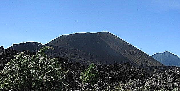
In 1943 the town of San Juan was buried by the Paricutín lava, the youngest volcano in the world. Do you know him?
When I was a child I got to hear stories about the birth of a volcano in the middle of a corn field; from the eruption that destroyed the town of San Juan (now San Juan Quemado), and from ashes that reached Mexico City. This is how I got interested in him Paricutin, and although in those years I did not have the opportunity to meet him, it never left my mind to ever go.
Many years later, for work reasons, I had the opportunity to take two groups of American tourists who wanted to walk through the volcano area and, if conditions allowed, to ascend it.
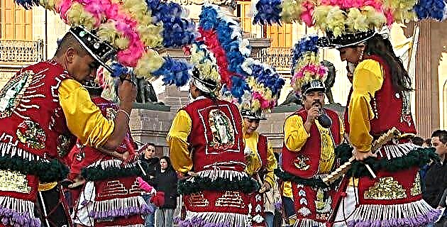
The first time I went, it was a bit difficult for us to get to the town from which Paricutín is visited: Angahuan. The roads were unpaved and the town barely spoke any Spanish (even now its inhabitants speak more Purépecha, their native language, than any other language; in fact, they name the famous volcano respecting its Purépecha name: Parikutini).
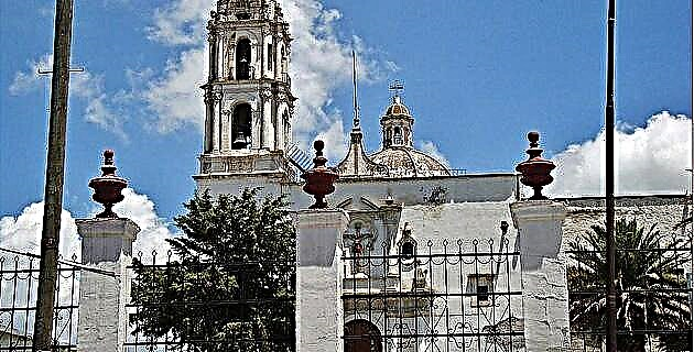
Once in Angahuan we hired the services of a local guide and a couple of horses, and we started the trek. It took us about an hour to get to where he was the town of San Juan, which was buried by the eruption in 1943. It is located almost on the edge of the lava field and the only thing that remains visible of this place is the front of the church with a tower that remained intact, part of the second tower, also from the front, but which collapsed, and the back of it, where the atrium was located, which was also saved.
The local guide told us some stories of the eruption, the church and all the people who died in it. Some of the Americans were very impressed by the view of the volcano, the lava field and the grim spectacle of the remains of this church that still remain.
Later, the guide told us about a place where lava is supposed to still flow; He asked us if we would like to visit him and we immediately said yes. He led us through small paths through the forest and then through the scree until we reached the place. The spectacle was impressive: between some cracks in the rocks a very strong and dry heat came out, to such a degree that we could not stand very close to them because we felt ourselves burning, and although the lava was not seen, there was no doubt that below the land, it kept running. We continued wandering through the scree until the guide led us to the base of the volcanic cone, to what would be its right side seen from Angahuan, and in a couple of hours we were at the top.
The second time I ascended to Paricutín, I was taking a group of Americans with me, including a 70-year-old woman.
Once again we hired a local guide, to whom I insisted that I needed to find an easier route to climb the volcano due to the age of the lady. We drove about two hours on dirt roads covered with volcanic ash, which caused us to get stuck a couple of times because our vehicle did not have four-wheel drive. At last, we arrived from the back side (seen from Angahuan), very close to the volcanic cone. We crossed the petrified lava field for an hour and began to climb a fairly well marked path. In just under an hour we reached the crater. The 70-year-old woman was stronger than we thought and she had no problem, neither in the ascent nor in returning to where we had left the car.
Many years later, when talking to the people of Unknown Mexico about writing an article about the ascent to Paricutín, I made sure that my old photos of the place were not ready to be published; So I called my fellow adventurer, Enrique Salazar, and suggested the ascent to the Paricutín volcano. He had always wanted to upload it, also excited by the series of stories he had heard about him, so we left for Michoacán.
I was surprised by the series of changes that have taken place in the area.
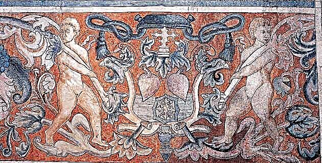
Among other things, the 21 km road to Angahuan is now paved, so it was very easy to get there. The inhabitants of the place continue to offer their services as guides and although we would have liked to be able to give someone the job, we were very short of economic resources. Now there is a nice hotel at the end of the town of Angahuan, with cabins and a restaurant, which has information about the Paricutín eruption (many photos, etc.). On one of the walls of this place there is a colorful and beautiful mural that represents the birth of the volcano.
We started the walk and soon we reached the ruins of the church. We decided to continue and try to reach the crater to spend the night on the rim. We had only two liters of water, a little milk and a couple of bread shells. To my surprise, I discovered that Enrique did not have a sleeping bag, but he said that this was not a big problem.
We decided to take a route that we later called the “Vía de los Tarados”, which consisted of not going along a path, but crossing the scree, which is about 10 km long, to the base of the cone and then trying to ascend it directly. We crossed the only forest between the church and the cone and began to walk on a sea of sharp and loose stones. Sometimes we had to climb, almost climb, some large blocks of stone and in the same way we had to lower them from the other side. We did it with all caution to avoid injury, because leaving here with a sprained foot or any other accident, no matter how small, would have been very painful and difficult. We fell a few times; others the blocks we stepped on moved and one of them fell on my leg and made some cuts on my shin.
We got to the first steam emanations, which were many and odorless and, up to a point, it was nice to feel the warmth. From a distance we could see some areas where the stones, which are normally black, were covered with a white layer. From a distance they looked like salts, but when we got to the first section of these, we were surprised that what covered them was a kind of layer of sulfur. A very strong heat also came out between the cracks and the stones were very hot.
Finally, after three and a half hours of fighting with the stones, we reached the base of the cone. The sun had already set, so we decided to pick up our pace. We ascended the first part of the cone directly, which was very easy because the terrain, although quite steep, is very firm. We arrive at the place where the secondary caldera and the main cone meet and we find a good path that leads to the edge of the crater. The secondary boiler emits fumes and a large amount of dry heat. Above this is the main cone that is full of small plants that give it a very beautiful appearance. Here the path zigzags three times to the crater and is quite steep and full of loose rocks and sand, but not difficult. We arrived at the crater practically at night; we enjoy the scenery, drink some water and get ready to sleep.
Enrique put on all the clothes he brought and I got very comfortable in the sleeping bag. We woke up many voices at night due to thirst - we had exhausted our water supply - and also to a strong wind that blew at times. We get up before sunrise and enjoy a beautiful sunrise. The crater has a lot of steam emanations and the ground is hot, maybe that's why Enrique didn't get too cold.
We decided to go around the crater, so we went to the right (seeing the volcano from the front from Angahuan), and in about 10 minutes we reached the cross that marks the highest summit that has a height of 2 810 m asl. If we had brought food, we could have cooked it over it, since it was extremely hot.
We continue our journey around the crater and reach the lower side of it. Here there is also a smaller cross, and a plaque in memory of the disappeared town of San Juan Quemado.
Half an hour later we arrived at our campsite, gathered our things and started our descent. We follow the zigzags to the secondary cone and here, luckily for us, we find a fairly marked path to the base of the cone. From there this path goes into the scree and becomes a bit difficult to follow. Many times we had to look for it to the sides and go back a bit to relocate it because we were not very excited about the idea of crossing the scree again like fools. Four hours later, we reached the town of Angahuan. We got in the car and returned to Mexico City.
Paricutín is certainly one of the most beautiful ascents we have in Mexico. Unfortunately the people who visit it have thrown away impressive amounts of garbage. In fact, I've never seen a dirtier place; the locals sell potatoes and soft drinks on the edge of the scree, very close to the destroyed church, and people throw paper bags, bottles and so on all over the area. It is a pity that we do not conserve our natural areas in a more adequate way. Visiting the Paricutín volcano is quite an experience, both for its beauty and for what it has implied for the geology of our country. The Paricutín, due to its recent birth, that is, from zero to as we know it now, is considered one of the natural wonders of the world. When will we stop destroying our treasures?
IF YOU GO TO PARICUTÍN
Take highway number 14 from Morelia to Uruapan (110 km). Once there, take Highway 37 towards Paracho and a little before reaching Capácuaro (18 km) turn right towards Angahuan (19 km).
In Angahuan you will find all the services and you can contact the guides who will take you to the volcano.