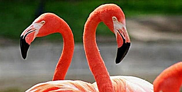
The state of Guerrero keeps in its territory an infinity of fragile underground wonders of which, however, little is known.
The state of Guerrero keeps in its territory infinity of fragile underground wonders of which, however, little is known.
Due to its geological conformation and strong orography, product of the great pressures and the introduction of the Cocos Plate under the North American continental for 90 million years - which originated enormous folds and elevations constituted by strata of marine animals rich in carbonate of calcium–, the state of Guerrero keeps in this gigantic limestone jewel box of 64,281 km2 of territory, infinity of fragile subterranean wonders in the form of caverns, chasms and rivers of which, however, little is known.
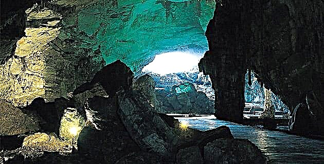
Most of the non-specialized visitors have limited themselves to the famous and legendary Cacahuamilpa Grotto, which, fitted out for tourism, consists of a large 1,300 m long gallery, decorated with multiple stalagmitic formations; to the underground rivers
San Jerónimo (5,600 m long) and Chontacoatlán (5,800 m), which, located 100 m vertically under the Cacahuamilpa Grotto, cut from part to part a limestone chain made up of the Tepozonal and Jumil hills; and to the beautiful Grutas de Juxtlahuaca, near Chilpancingo, also equipped for tourism.
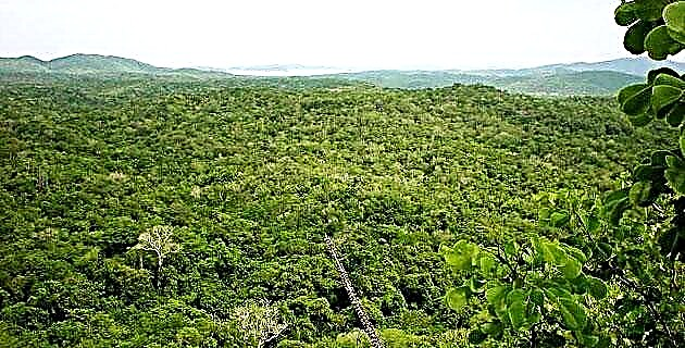
However, it is the Guerrero region known as Sierras del Norte, adjacent to the states of Mexico and Morelos, that has attracted the most attention of explorers and scholars of speleology for more than thirty years, and where they have been documented many cavities.
One of them, located near the town of El Gavilán, municipality of Taxco de Alarcón and which for years has been used as a school for many cavers in the Valley of Mexico, is paradoxically one of those wonders about which little has been written.
HISTORY OF THE PLACE
It was Mr. Jorge Ibarra, from the Andean Club of Chile-Mexico Section, who on December 20, 1975 showed this cavity to Mr. José Montiel, a member of the Draco base association. At that time, a small siphon located 800 m from the entrance was considered as the end of the route, which allowed observing a reduced air space; However, the desire to explore and search beyond what for others seems to end, and which has been the key to great speleological discoveries, allowed Mr. José Montiel to overcome this first obstacle.
Examining the reduced passage before, and after several attempts to progress through the flooded cathole and not a few scolding from his worried companions, Montiel managed to pass the obstacle, which he baptized as the "Crocodile Pass", since when crossing it he had to remove himself The helmet, and with his head zigzagging between the formations of the vault, holding his breath and trying not to move the water too much, since the level of it reached the level of his eyes, he managed to pass on the other side.
As his companions could not do it, they had to dig, with the help of some stones, until they managed to lower the level of the floor and thus they could meet him, to finally find a series of beautiful meanders, unexplored until then, with pools of water transparent, between immaculate walls of polished white and black limestone where it was advanced, without resisting the attraction of the magical and unknown spelunca.
After overcoming this key step, the incursions of the Draco group become more constant, and it is on the ninth visit, December 28, 1976, when three people arrive at the siphon-laminator at the bottom of La Joya. Many people have entered this drain (so called because it captures a lot of water, so it cannot be visited in the rainy season); some only a few meters, others have descended one or more shots, and the few have managed to reach the bottom, but nobody enters their branches "The arm of the window" and "The arm of the gours", which emerge from the main branch and which are the most visible.
The exploration of these secondary branches, with narrow passages, where the explorer has to eliminate rocky obstacles, smearing the face between the ceiling and the almost completely flooded floor, crawling with difficulty to be able to advance between the water, sand and stones through a claustrophobic space, it is a natural brake for those who do not have the adequate preparation, but in return it offers the daring fragile and beautiful formations; hence its apt name.
The possibility that this cavity offers us to discover new passages is unmatched, because despite the time that has elapsed and being visited by so many groups, it is still possible to explore –in the strict sense of the word– and obtain as many or more satisfactions as those who experienced its first explorers almost 25 years ago.
DESCRIPTION
The La Joya drain has a route of 2,960 m in its main branch, and 3,400 m if “The window arm” is included, reaching a drop, that is, a depth of 234.71 meters.
Its entrance is located about 900 m southwest of the town of El Gavilán, at the bottom of a hill. Following a small dry riverbed, a large entrance is guessed when approaching, but there is no such, since it is about small accesses caused by several landslides. One of these accesses, the most used, is through a fissure with a 5 m draft; although there are others on the right wall where you can de-climb, but the stream bed ends there.
Going down this access, you go through a short and somewhat tight passage that leads to one 30 m long by 18 m wide, where daylight filters through the collapsed blocks at the entrance. Then the passage narrows and we arrive at a place where we de-climb a bit, to find the 15 m curtains draw, where a rope is attached to a natural formation on the right side and a few meters from it. You descend having a water mirror in the background; it is a pool located in a small and beautiful room of about 7 m in diameter; This is where the active part begins. About 25 m further on and on the left side is "The arm of the gours" (limestone formations in the form of stepped pools), and going a little further, a good place to camp. At 20 meters from there the vault almost meets the floor, forming what is called a "rolling mill", 160 m from the entrance.
Passing the rolling mill and after a few gours the vault rises to 10 m high. We continue along a beautiful passage for 200 m to reach a collapse zone, which is circumvented by its right wall, called “Paso de la slidilla”, which is nothing more than a descending laminator. At about 130 m from small pools we find the “Turtle Pass”, the first step “on all fours” where the chest is wet or it is chosen to go through the “Tubo del fakir”, an alternate pass dotted with stalactites and tiny stalagmites, to after 100 m, reach the third shot, called "The backpack", of 11 meters.
What continues is truly beautiful: a cluster of astonishing impressions at each bend, pool after pool and de-escalation after de-escalation, to descend a fourth 10 m shaft known as “La poza”, following the route in a zigzagging conduit full of fantastic formations that lead us to the "Crocodile Pass", 7 m long.
The meanders continue to awaken the visitor's interest in moving forward; On the right hand side is "The arm of the window" and then an 11 m shaft known as "The window", and immediately there is the largest and most spectacular of the cavity, to which you descend under the breeze of a waterfall.
The main passage continues for 900 m between beautifully sculpted walls and some de-climbed until it reaches the bottom of the drain. The La Joya tour is carried out in an average of 25 hours by a group of between five and ten people, all with adequate equipment and training.
In addition to La Joya, there are other cavities of similar morphology in the area, with a large number of small shafts and sub-horizontal galleries that follow the stratification planes. These are the resumideros de Zacatecolotla (1,600 m long), Gavilanes (1,100 m) and the Izonte (1,650 m). The first two drain to the east, to re-emerge in the cave of Las Granadas; On the other hand, the Izote does it towards the north, to exit in the cave of Las Pozas Azules (1,400 m). This indicates the presence of an underground watershed that does not coincide with the surface watershed.
It is important to say that before venturing into a cavity not equipped for tourism, it is convenient to acquire knowledge and practice in a prestigious speleological organization, since pseudo-instructors abound, real potential accident factories that neglect ethics and safety.
SPELEOLOGICAL INFORMATION
The La Joya reservoir is located in the limestones of the Morelos formation of Albiano-Cenomaniana age, at an altitude of 1,730 meters above sea level. It is located on the topographic map of inegi 1:50 000 "Taxco" at coordinates 18 ° 35'50 '' north latitude and 99 ° 33'38 '' west longitude.
The humidity is very high, so it is suggested to wear 3/4 neoprene, polypropylene or polartec clothing under the overalls for a more comfortable ride. Artificial anchors are standard and millimeter. As de-escalations abound, it is advisable to carry some extra bolts and short ropes.
IF YOU GO TO THE JOYA SUMMARY
It can be reached in two ways; the first is taking highway no. 95, from Puente de Ixtla (Morelos) to Taxco, and at approximately km 49 take the deviation to the right at the junction that takes federal highway no. 95 leads to the Cacahuamilpa Grottoes. At about 8 km there is a sign on the left that says Parada El Gavilán, where you will find some houses. Ask for Mrs. Olivia López, who can prepare a delicious and inexpensive meal for you, or for Mrs. Francisca, with whom you can register to have control of any unforeseen event; also, they will inform you how to get to the drain.
The second is through federal highway no. 95, arriving at Cacahuamilpa and continuing to Taxco. 10 minutes from the town of Acuitlapan you will find the sign, but on the right.
If you go by bus, take it to Taxco and ask the driver to drop you off at the cruise ship, if you are going by highway.