La Encrucijada is one of the most beautiful reserves in the state of Chiapas. Located along the Pacific coastline that includes the municipalities of Mazatán, Huixtla, Villa Comaltitlán, Acapetahua, Mapstepec and Pijijiapan.
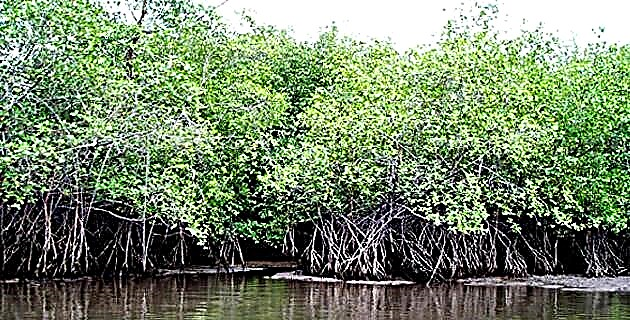
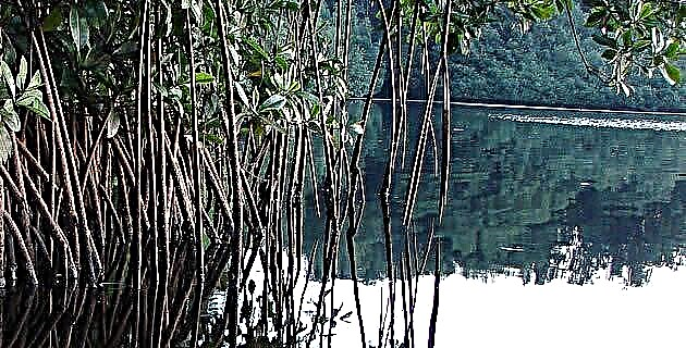
It was decreed a Protected Zone on June 6, 1995 through the Official Gazette. It has an area of 144,868 hectares of ejidal, communal, private and national lands. Since the date of the Decree, it has been dedicated to the conservation and management of ecosystems of enormous ecological importance and great economic potential. The abundance of mangroves in coastal areas stands out, as well as channels and flooded and seasonally flooded lands.
For the traveler it is an extraordinary spectacle. La Encrucijada is part of the Manglar Zaragoza Natural Park on latitude 15º 10 ′ and 93º 10 ′ of latitude.
The heat is humid and exceeds 37ºC in the shade. Territory in which there are no notable visual guides. Everything around us is the same: 360º of roots stuck in the water, vertical stems and trunks, disheveled branches that by dint of copying each other multiply to infinity.
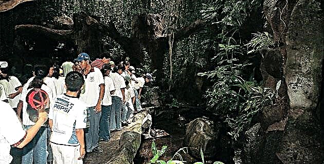
Although La Encrucijada is not a tourist site, it is allowed to reach this place with an express permission from the Institute of Natural History, based in Tuxtla Gutiérrez. It is worth mentioning that in this area there is a lack of all kinds of services, fresh water is scarce and in the area around the reserve only three families live; the possibility of getting food is almost nil.
HOW TO GET
To get to this place, we have deviated from the Pacific coast highway, number 200, which goes to Tapachula and the border with Guatemala. The deviation is in the population of Escuintla (the pre-Hispanic ltzcuintian, abundant in dogs). A few kilometers ahead you enter Acapetahua; From there, approximately 15 kilometers of dirt road are transported by vehicle to reach the Embarcadero de las Garzas.
THE PIER OF LAS GARZAS
Here, cargo trucks are transmuted into numerous outboard motorized canoes to drive all kinds of food and merchandise into a secluded, empty world with intricate access: its labyrinthine canals. Entering any of the hundreds of canals in the estuary is to enter a region difficult to conceive: a world in which you never really know where is water, where is land, or where is a mixture of both.
SURROUNDED BY THE JUNGLE
Time seems to go back as one continues to penetrate the mangroves. Everything is more primitive, more elemental, and there is less and less human presence. If it is not on board a "cayuco", one is unable to move. It can be properly said that there are a hundred million bars on either side of each canal and that one is caged. In the midst of so much loneliness, we end up understanding that this wonderful world of infinite freedom is, at the same time, a gigantic prison from which many people will never leave.
Inside the reserve there are no roads. To make way between the jungle and the swamps, the researchers who have traveled the place had to cut down trees to walk over the trunks and fallen branches, using them as bridges. Sometimes these bridges, which protrude from the vegetation hidden by the mud, rise to one, two and more meters in height, and the trunks or branches are so thin that they have to be crossed in an acrobat's balance, with the danger of have an accident or, in the best of cases, a good scare from scratches.
The atmosphere of the island is idyllic within the supreme simplicity that life assumes in this place. As we have already said, to get here there is no other vehicle than the boat, either motorized or rowing, so that the isolation is virtually constant, and traveling to the nearest town, Acapetahua, means spending a few hours. Heading from the island towards the southern end of the estuary and whose name eloquently describes it, we find La Encrucijada.
YOUR ACTIVITIES
The most important productive activities in the area are agriculture and fishing, and in second place are forestry and agriculture.
At the bottom of the immense lagoon appears a small island, such as those that are only known from the stories of old novels about Polynesia. On the island of La Palma or Las Palmas there are about a hundred families dedicated entirely to fishing, who have electric current generated by a small local plant. There is a primary school here, but everything else comes from the sea (half a kilometer away) and the immediate lagoon.
MORE CROSSROADS URGENT
Ecological reserves such as La Encrucijada should exist in each of the states that make up the Mexican Republic, in those areas where some type of wildlife still survives, the chaotic invasion of lands, immoderate hunting and logging, among other human calamities. , threaten to end the lives of our animals.
If other countries import animals to repopulate their forests, why in Mexico do we not worry about the survival of the animal species that still inhabit our mountains?
The black list of endangered animals is already very long and is increasing every day. If ecological reserves like La Encrucijada are not created, the time will come when our children will not have the opportunity to meet tapirs or ocelots, because there will no longer be zoos. They will contemplate the specimens of our fauna only in photographs and they will say: how beautiful these animals were! Why did they finish them? And that question without an answer now, the less we can answer it tomorrow.