The forces of earth, fire, and water explain mountains, plains, and aridity, but they didn't tell us much about the sand itself. How is it that such a quantity of sand has reached Samalayuca?
The forces of earth, fire, and water explain mountains, plains, and aridity, but they didn't tell us much about the sand itself. How is it that so much sand has reached Samalayuca?
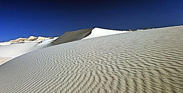
Barely fifty kilometers south of Ciudad Juárez is a place that is both inhospitable and fascinating. One approaches him on the Pan-American Highway through the immeasurable Chihuahuan plain. Whether the traveler starts the journey from the north or from the south, the plain covered with squat shrubs or yellowish pastures dotted with Hereford “white-faced” cattle is gradually transformed into colonies of a homogeneous beige hue. The horizontal lines of the flat terrain give way to gentle curves, while the sparse vegetation ends up disappearing. The usual signs of the Mexican northern land, poor but alive, dissolve in a panorama so desolate that it seems rather Martian. And then the classic image of the desert emerges, the majestic and immense spectacle like a sea paralyzed in waves of sand: the Samalayuca dunes.
Like the dunes of a beach, these dunes are sandy hills of all sizes, accumulated by ancient erosion processes. And although most of the Mexican territory is desert, in very few places arid conditions exist such that they allow the existence of mountains of fine sand like those. Perhaps only the Altar desert, in Sonora, and the Vizcaíno desert, in Baja California Sur, or the Viesca area, in Coahuila, are comparable to this place.
With all their rarity, the Samalayuca dunes are not strange for the traveler on the route that connects Ciudad Juárez with the state capital, since the Pan-American Highway and the Central Railroad track cross the area through its narrowest part. However, as with many other natural wonders, one does not usually give oneself the opportunity to stop and explore them, in such a way that they keep their mystery to themselves.
Determined to leave behind that condition of mere panoramic observers, we had a formidable encounter with the most primitive forces of nature.
THE FIRE
The dunes welcomed us with a breath of light and warmth. Leaving the trunk at noon, we not only lost the comfort of the air conditioning, but we entered a blindingly bright environment. Walking among the ripples of pure light sand forced us to direct our eyes towards the sky, because there was no way to rest it on such dazzling ground. At that moment we discovered the first feature of that kingdom: the dictatorship of solar fire.
That surprising solitude certainly shares the harshness of the Chihuahuan desert, but also multiplies them. Deprived of moisture and a significant vegetation layer, its heat depends almost entirely on the Sun. And although geography books indicate a pleasant average annual temperature of about 15 ° C, there is probably no other part of the country where the daily temperature variations and yearly - are so extreme.
THE EARTH
After that first impression, it was necessary to face the legendary thermos of the man in the desert: getting lost in a labyrinth without walls. The Samalayuca dunes belong, like the entire north of Chihuahua and Sonora, to a geographic region that spans several western regions of the United States (mainly Nevada, Utah, Arizona and New Mexico) known as the “Cuenca and Sierra” or, in English, basin-and-range, formed by dozens of basins separated from each other by small mountain ranges, which generally follow a south-north direction. Such detail serves as a consolation to the walkers of the sand: no matter how much one sinks into its chasms, at any moment one can orient oneself through these relatively short mountain ranges, but half a kilometer high above the level of the plain. To the north rises the Samalayuca mountain range, behind which is the decayed homonymous town. To the northeast is the Sierra El Presidio; and to the south, the mountains La Candelaria and La Ranchería. Thus, we always had the help of those formidable peaks that guided us like beacons to ships.
WATER
If the mountains are millions of years old, the plains are, on the other hand, much more recent. The paradox is that they were produced by that water that we did not see anywhere. Tens of thousands of years ago, during the Pleistocene glaciations, the lakes formed a large part of the “basin and mountain range” region by depositing sediments in the spaces between the mountain ranges. When the continental glaciers finished retreating more or less twelve thousand years ago (at the end of the Pleistocene) and the climate became more arid, most of these lakes disappeared, although they left behind a hundred depressions or closed basins where the little water that rushes down does not drain into the sea. In Samalayuca the torrents are lost in the desert instead of spilling into the Rio Grande, just 40 kilometers to the east. The same occurs with the not too distant Casas Grandes and Carmen rivers, which end their journey in the Guzmán and Patos lagoons, respectively, also in Chihuahua. That a large body of water once rested on the dunes is shown by certain marine fossils found under the sand.
An overflight in the small Cessna plane of captain Matilde Duarte showed us the wonder of El Barreal, a lake perhaps as extensive as Cuitzeo, in Michoacán, although it only revealed a brown, flat and dry horizon ... Of course, it only has water after of the downpours.
You might think that the little rain that falls on the dunes should run towards El Barreal; however, this is not the case. The maps do not mark any stream that leads in that direction, even though the “virtual” side is the lowest point in the basin; there are no signs of any torrent in the Samalayuca sand. With the rains, the sand must absorb the water very quickly, although without taking it too deep. Something amazing was the spectacle of a water hole almost at the intersection of the Samalayuca mountain range with the road, a few meters from one of the most typically desert spots in North America ...
WIND
The forces of earth, fire, and water explain mountains, plains, and aridity, but they didn't tell us much about the sand itself. How is it that so much sand has reached Samalayuca?
The fact that the dunes are there and nowhere else in the northern highlands is significant, though mysterious. The shapes that we came from the plane were whimsical, but not casual. To the west of the dividing line drawn by the road were two or three large sandy hills. On the other side, almost on the eastern edge of the area, there was a long series of towering dunes (the most visible from the road) like those that geographers call the “barjánica chain”. It was a kind of mountainous area much higher than the rest. How much? Captain Duarte, a shrewd aviatex-mex, ventured an answer in the English system: perhaps up to 50 feet (in Christian, 15 meters). Although it seemed a conservative estimate, it may be indicative enough: that roughly equates to a six-story building. The land surface may well show elevations much greater than these; The incredible thing is that it consigns it with a material as flimsy as grains of sand of less than a millimeter in diameter: such is the work of the wind, which has accumulated that amount of sand in the north of Chihuahua. But where did he get it from?
Mr. Gerardo Gómez, who once trained to walk in the dunes - an effort difficult to imagine - told us about the sand storms in February. The air becomes so cloudy that it is necessary to drastically reduce the speed of the vehicles and pay extraordinary attention not to lose the asphalt strip of the Pan-American Highway.
The dunes were probably overgrown to the east during our excursions, but that it was the middle of June and in the spring the dominant currents blow from the west and southwest. It is also quite possible that such winds only "accommodated" the grains of sand in that peculiar way. It may well be that the sand has been deposited there for millennia by stormy "nortes" that collect grains in what is now the United States. It is those "north" that must cause the storms mentioned by Mr. Gómez. However, they are only hypotheses: there are no specific climatic studies for the region that answer the question about the origin of this sand.
Something that is definitive, and so far obvious, is that the dunes migrate and they do so quickly. The Central Railroad, built in 1882, can testify to its mobility. To prevent the sand from “swallowing” the tracks, it was necessary to nail two protective lines of thick logs to keep it away. That led us to one last consideration as we climbed the Samalayuca mountain range to get a perspective from above: is the area of the dunes growing?
The area of pure sand must have at least 40 km from east to west and 25 latitude in its widest parts, for a total area of approximately one thousand square kilometers (one hundred thousand hectares) .The Dictionary of Chihuahuan History, Geography and Biography However, it gives figures twice as large. It should be clarified that the sand does not end with the dunes: the limit of these is located where the vegetation begins, which fixes and flattens the ground, in addition to sheltering countless hares, reptiles and insects. But the sandy terrain stretches west, northwest, and north to El Barreal and the New Mexico border. According to the aforementioned dictionary, the entire basin that frames the dunes covers the territory of three municipalities (Juárez, Ascención and Ahumada) and exceeds 30 thousand square kilometers, something like 1.5% of the country's surface and a sixth of the of the state.
From there we also discovered what appeared to be petroglyphs on one of the rocks in a natural amphitheater: dots, lines, outlines of shaved human figures on a two-meter-high wall, similar to other rock art remains in Chihuahua and New Mexico. Were the dunes that large for the authors of those petroglyphs?
Surely the pioneer settlers of America, in their tense migration to the south, did not know them. There were still large lakes around when the first hunter-gatherers arrived. The climate was much more humid and the environmental problems that we suffer today did not exist.
Perhaps the Samalayuca dunes have been growing for ten thousand years, which suggests that previous generations enjoyed a more gentle and hospitable region. However, that also means that they did not enjoy a sunset like the one we experienced on that occasion: the golden Sun setting behind an imposing landscape of dunes, a gentle dance of the desert caressed by the hands of the wind.
IF YOU GO TO THE SAMALYUCA DOCTORS
The area is about 35 km south of Ciudad Juárez on federal highway 45 (the Panamericana). Coming from the south, it is 70 km from Villa Ahumada and 310 km from Chihuahua. On the highway you can see the dunes for about 8 km on both sides.
From the very edge of the road you can reach some ridges of pure sand with just a few steps. However, if you are looking for the highest dunes hoya to do some detours. Several gaps coming off the highway can bring you closer. If you drive a car, always be careful to check the firmness of the road and not get too close because it is very easy to get stuck in the sand.
There are two recommendable gaps. The first is north of the deviation that leads to the town of Samalayuca. It heads east and skirts the Sierra El Presidio until it reaches the northeast corner of the sandy area, from where you can walk into it. The second is born on the southeastern slope of the Sierra Samalayuca, exactly where a judicial police checkpoint usually occupies. “That gap heads west and leads to some ranches from which you can continue on foot (to the south). For a panoramic view, climb from the checkpoint to the Sierra Samalayuca as high as you like; the paths there are not very long or steep.
If you are looking for tourist services (accommodation, restaurants, information, etc.), the closest are in Ciudad Juárez. The town of Samalayuca barely has a couple of grocery stores where you can buy cold sodas and snacks.
Source: Unknown Mexico No. 254 / April 1998
Journalist and historian. He is a professor of Geography and History and Historical Journalism at the Faculty of Philosophy and Letters of the National Autonomous University of Mexico where he tries to spread his delirium through the rare corners that make up this country.