Beyond recreational activities, this place offers true natural sanctuaries where adventure lovers will be caught in awe.
Due to its privileged position in the equatorial zone, right at the vertex that joins Veracruz with Chiapas, this hidden corner of the Tabasco geography is benefited by abundant rains, which explains the existence of exuberant tropical vegetation, dozens of waterfalls, rivers, canyons and a steep terrain, which was the scene where the Zoque culture developed more than a thousand years ago.
Willing to explore places never seen before, we arrived at the town of Malpasito to stay four days. There we stayed in a comfortable cabin and hired the services of Delfino, an expert with knowledge of the region who that morning would guide us to our first objective: the hill of La Copa.
The cup
It is a rock formation located on the top of a hill, 2 kilometers east of the town and 500 meters high. After two hours we reached the summit, everything was spectacular: the intense blue sky dotted with white clouds and the immense green plain that stretches to the horizon with the Grijalva river and the Peñitas dam.
Up close, this rocky bulwark is much larger than it appears. We calculate that it is about 17 meters high and weighs 400 tons, but what really surprised us, in addition to its resemblance to a glass, is that it has withstood the onslaught of water and wind, seismic movements and volcanic eruptions, without collapsing. all when considering that it is in precarious balance on the edge of a cliff.
La Pava
This waterfall is one of the most beautiful and accessible, it is located 20 minutes from Malpasito and takes its name from the hill of La Pava, a triangular mass crowned by a rock in the shape of this curious little animal. Heated from the walk, we dove into one of the pools formed by the crystal clear water when it falls from 20 meters.
The Flowers and The Twins also surprise
The next day we left very early to the town of Francisco J. Mújica, but first we stopped at the Las Flores waterfall, more than 100 meters high, visible from miles away due to the white of its flow. The name comes from the orchids, ferns and exotic plants that abound in the surroundings. Our guide explained that most of the year it has water, but from September to November its volume increases and a veil forms that billows driven by the wind and that, seen from a distance, seems to fall in slow motion.
The journey could not be more grandiose, as Aguaselva occupies a mountainous region of limestone and igneous rock, home to deep canyons and narrow valleys, with peaks ranging from 500 to 900 meters high, whose origin dates from 40 to 65 million years.
Kilometers after Las Flores, on the left side of the stone wall that borders the road, we were struck by two waterfalls with a height of 70 meters, separated from each other by a narrow strip. We stopped the vehicle and did not walk much, only 50 meters, until we contemplated a jungle scene with the Las Gemelas waterfall as a background.
Signs of life
At midmorning we arrived at the Zoque town of Francisco J. Múgica, which contains the largest amount of carved stones in the entire state. For this day, the patriarch of the town, Don Toño, suggested that we visit the petroglyphs and a nearby waterfall.
The carved stones are at the exit of the town, and as one advances through the valley, more and more appear. Some are large rocks up to 7 meters high, with five, six, and up to ten engravings depicting birds, monkeys, turtles, snakes and other animals, geometric figures, and human beings. There are more than 200, but none compares with the magnificence of El Abuelo, it represents a man with a beard, who in a seated position and reverential attitude, drinks from a gourd.
The presence of these rock works and 36 archaeological sites, in addition to other testimonies, have led archaeologists to postulate that Aguaselva was inhabited in early times by a people of hunter-gatherers.
Nearby, after crossing a river and going down a path, we reached the Francisco J. Múgica waterfall, which is 40 meters high and although it is not the largest, the natural scenery that surrounds it is overwhelmingly beautiful; Strong guanacastes, sapotes, mulattos, ramones and other trees as peculiar as the matapalo, form a vegetal wall with an infinity of species hitherto unknown to man.
Back in town, we got our strength back with a delicious chicken broth. Some locals have opted for alternative tourism and offer food and lodging in cabins with all services, sale of handicrafts and even a spa service with massages and cleanses with herbs.
Los Tucanes Waterfall
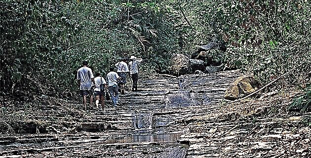
At 6:00 am the horses were ready and we headed towards Los Tucanes, between steep ups and downs, accompanied by the song of the birds and the cry of the saraguatos. After continuing on foot through a ravine, we were finally in front of the waterfall, whose background is a 30-meter-high rock curtain to which trees, vines and plants provide a paradisiacal image. In spring, when the heat becomes intense, this site is visited by flocks of birds, especially toucans, hence its name.
Veil
The stream continues and 100 meters later it disappears with a great roar down a gorge. Don Toño explained to us that this is the most spectacular waterfall of all, but it was necessary to go down another route to reach it. We might as well rappel down, but not everyone knew the technique, so we made our way up a steep hillside to a fantastic canyon. The water has shaped the rock in such a way that the great walls, canals and cavities give life to a marvelous painting, topped by the Velo de Novia waterfall, which falls dazzlingly from a height of 18 meters.
Finally, after touring this land of jungle and water, our adventure ended at the Malpasito archaeological site, a ceremonial center of the Zoque culture inhabited in the Late Classic period, between the years 700 and 900 of our era, from which we said goodbye. of our friends and we admired for the last time the incredible landscape of Aguaselva.
How to get to Aguaselva
Aguaselva is located in the Sierra de Huimanguillo, in the southwest of the state. You enter the federal highway 187 that goes from the city of Cárdenas, Tabasco, to Malpaso, Chiapas, turning left a couple of kilometers before reaching the town of Rómulo Calzada.
If you start from Tuxtla Gutiérrez, you must take federal highway 180.