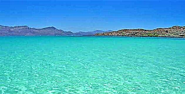
The maximum depth of Sinforosa is 1 830 m at its viewpoint called Cumbres de Huérachi, and at its bottom runs the Río Verde, the most important tributary of the Río Fuerte.
The maximum depth of Sinforosa is 1 830 m at its viewpoint called Cumbres de Huérachi, and at its bottom runs the Verde River, the most important tributary of the Fuerte River.
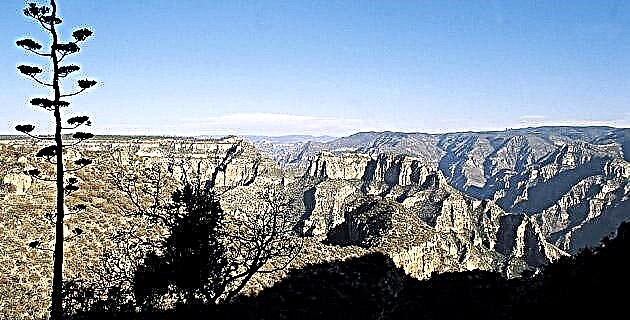
When we hear about ravines or canyons in the Sierra Tarahumara, the famous Copper Canyon immediately comes to mind; However, in this region there are other ravines and the Copper Canyon is not the deepest, or spectacular. Those honors are shared with other canyons.
From my point of view, one of the most impressive in this entire mountain range is the little known Sinforosa ravine, near the town of Guachochi. Mrs. Bernarda Holguín, a well-known provider of tourist services in the area, has rightly called it “ the queen of the canyons ”. The first time I observed it, from its viewpoint at Cumbres de Sinforosa, I was more than surprised by the fantastic view and the depth of its landscape, nothing similar in everything I had seen in the mountains until then. Part of what is spectacular about its landscape is that it is very narrow in relation to its depth, which is why it stands out worldwide. The maximum depth of Sinforosa is 1 830 m at its viewpoint called Cumbres de Huérachi, and at its bottom runs the Verde River, the most important tributary of the Fuerte River.
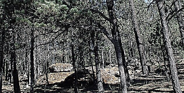
Later I had the opportunity to enter the Sinforosa through its different side canyons. One of the most beautiful ways to enter this canyon is through Cumbres de Sinforosa, from where a path starts that goes down forming many curves between a scene of imposing vertical walls. In just over 6 km, which are covered in about 4 hours, you descend from the pine and oak forest of a semi-arid and semi-tropical landscape at the bottom of the ravine. The trail descends between quite deep gorges and passes next to the unknown series of Rosalinda waterfalls, of which the highest waterfall is 80 m and one of the most beautiful waterfalls in the region.
What surprised me the most the first time I went down this path was to find, under a rocky shelter, the small adobe and stone house of a Tarahumara family who, in addition to living in such a remote place, had a beautiful view of the ravine . The extreme isolation in which many Tarahumara still live is striking.
On another occasion I went down through Baqueachi, near Cumbres de Huérachi; through here a lateral canyon covered with a lot of vegetation is discovered where pines mix with pitayas and wild fig trees, reeds and brambles. It is a curious jungle that due to its inaccessibility preserves some pines and táscates over 40 m high, something already rare in the mountains. Among all this vegetation runs a very beautiful stream that has beautiful pools, rapids and small waterfalls, whose attraction is, without a doubt, the Piedra Agujerada, since the channel of the stream passes through a hole in a large rock and returns immediately below in the form of a beautiful waterfall of about 5 m of fall, inside a small cavity that is surrounded by vegetation.
Another interesting route is to start at the Cumbres de Huérachi, as it presents some of the most spectacular views of Sinforosa. It is also the path that has the greatest unevenness of the entire mountain range in a short distance: in 9 km you descend 1 830 m, the deepest part of this ravine. Along this route you walk for 6 or 7 hours until you reach the community of Huérachi, on the banks of the Verde River, where there are orchards of mangoes, papayas and bananas.
There are different paths where you can go down to the river, both on the Guarochi side and on the “La otra sierra” side (as the people of Guachochi call it on the opposite bank of the ravine); they are all beautiful and spectacular.
AT THE BOTTOM OF THE BARRANCA
Without a doubt, the most impressive thing is to cross the ravine from the bottom, following the course of the Verde River. Very few have made this journey, and without a doubt it is one of the most beautiful routes.
Since the 18th century, with the entry of missionaries to this region, this ravine was known by the name of Sinforosa. The oldest written record that I found about a tour of this canyon is in the book El México Desconocido by the Norwegian traveler Carl Lumholtz, who explored it 100 years ago, possibly going down from Cumbres de Sinforosa to leaving in Santa Ana or San Miguel. Lumholtz mentions it as San Carlos, and it took him three weeks to travel this section.
After Lumholtz I only found the record of a few more recent declines. In 1985 Carlos Rangel came down from "the other sierra" starting in Baborigame and leaving through Cumbres de Huérachi; Carlos actually only crossed the ravine. In 1986 the American Richar Fisher and two other people tried to cross the steep part of Sinforosa by raft but failed; Unfortunately, in his story, Fisher does not indicate where he started his journey or where he started.
Later, in 1995, the members of the Speleology Group from Cuauhtémoc City, Chihuahua, walked for three days at the bottom of the ravine, descending through Cumbres de Sinforosa and leaving through San Rafael. In addition to these, I have learned of at least two other crossings that foreign groups made on the river, but there is no record of their trips.
During the week of May 5 to 11, 1996, Carlos Rangel and I, accompanied by two of the best guides in the region, Luis Holguín and Rayo Bustillos, traveled 70 km within the steepest part of Sinforosa, descending through the Cumbres from Barbechitos and leaving through the Cumbres de Huérachi.
The first day we reached the Verde River going down the winding path of Barbechitos, which is quite heavy. We find a large terrace that is occasionally inhabited by the Tarahumara. We bathe in the river and observe some simple dams, called tapestes, that the Tarahumara build to fish, because catfish, mojarra and matalote abound in that place. We also saw another type of reed structure that they also use for fishing. What surprised me is that Lumholtz describes this same way of fishing as the Tarahumara; Then I felt that we were entering a world that has not changed much in the last hundred years.
The following days we walked between the canyon walls, following the course of the river, among a universe of stones of all sizes. We crossed the river with water up to our chests and had to jump between the rocks on several occasions. The walk was quite heavy coupled with the strong heat that is already felt in that season (the maximum record was 43ºC in the shade). However, we enjoyed one of the most impressive routes in the entire sierra and perhaps in Mexico, surrounded by gigantic stone walls that on average exceed one kilometer in height, as well as beautiful pools and places that the river and the ravine offered us.
THE MOST BEAUTIFUL PLACES
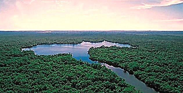
One of them was the site where the Guachochi River joins the Verde River. Nearby are the ruins of the old Sinforosa ranch, the one that gave this ravine its name, and a rustic suspension bridge so that people can pass to the other side when the river rises.
Later, in a place called Epachuchi, we met a family of Tarahumara who had come down from "the other sierra" to collect pitayas. One told us that we would go two days to Huérachi; However, as I have seen that the chabochis (as the Tarahumara tell us to those of us who are not) spend three times as long as they travel anywhere in the mountains, I calculated that we would do at least six days to Huérachi, and so it was . These Tarahumara had already been at the bottom of the ravine for several weeks and their only load was a bag of pinol, everything else they need is obtained from nature: food, room, water, etc. I felt weird with our backpacks that weighed about 22 kilos each.
The Tarahumara believe that nature gives them little because God has little, since the Devil has stolen the rest. Yet God shares with them; That is why, when the Tarahumara invited us from his pinole, before taking the first drink he shared with God, throwing a little pinole to each of the cardinal points, because Tata Dios is also hungry and we must share what he gives us .
In a place that we baptize with the name of the Great Corner, the Verde River turns ninety degrees and forms a wide terrace. There, two lateral streams flow through impressive ravines; there was also a beautiful spring in which we refreshed ourselves. Near this site we saw a cave where some Tarahumara live; It had its large metate, and outside there was a “coscomate” -a primitive barn that they make with stone and mud- and the remains of the place where they make the tatemado mezcal, which they prepare by cooking the heart of certain species of agave and which is very food rich. Ahead of the Great Corner we passed an area of huge rocky blocks and we found a way between the holes, they were small underground passages that made it easier for us to walk, since in some cases they were almost 100 m and the river water itself ran between them.
On the way there was a Tarahumara family who planted chili on the river bank and fished. They fish by poisoning the fish with an agave they call amole, the root of a plant that releases a substance into the water that poisons the fish and thus easily catch them. On some ropes they had several fish hung already open and without guts to dry them.
The junction of the San Rafael stream with the Verde river is very beautiful; There is a large palm grove there, the largest I have seen in Chihuahua, and the stream forms a 3 m waterfall just before joining the Verde River. There are also abundant alders, poplars, weavers, guamúchiles and reeds; all surrounded on both sides by the kilometers vertical walls of the canyon.
A place where the river formed a great meander that makes a 180º turn, we call it La Herradura. Here two very spectacular lateral ravines meet because of their closed and vertical walls, and with the sunset lights, visions that seemed fantastic to me are projected. In La Herradura we camped next to a beautiful pool and as night entered I had to see how the bats flew along the water catching mosquitoes and other insects. The scenery in which we were immersed amazed me, we were surrounded by a world of vertical walls between huge rocks, product of millenary collapses.
The only important current that descends in this section of "the other sierra" is the Loera river, which descends from Nabogame, a community near Guadalupe and Calvo. The union of this with the Green is spectacular, since two huge ravines come together and form large pools that must be crossed by swimming. The site is beautiful and it was a prelude before reaching the Huérachi community. Passing the Loera we camped at the foot of the imposing rock of Tarahuito, a stone point that rises a few hundred meters in the middle of the ravine. There it is, waiting for the climbers.
Finally we arrived at Huérachi, the only community that existed in the steep part of the Sinforosa ravine, since at present it is practically abandoned and only four people live there, three of them are workers of the Federal Electricity Commission, who daily they make gauges in the river and attend the meteorological station. The people who lived in this place decided to migrate to the Cumbres de Huérachi, almost two kilometers up the ravine, due to the too hot climate and isolation. Now, their little houses are surrounded by beautiful orchards where papayas, bananas, oranges, lemons, mangoes and avocados abound.
We leave the ravine by the path that goes to Cumbres de Huérachi, which is the largest slope in the entire mountain range, if you climb the deepest part of the ravine, Sinforosa, which has a drop of almost 2 km, the ascent It's heavy, we did it in almost 7 hours including breaks; however, the landscapes seen compensate for any fatigue.
When I reread the book El México Desconocido by Lumholtz, specifically the part where he describes Sinforosa's journey 100 years ago, it struck me that everything remains the same, the ravine has not changed in all those years: there are still the Tarahumara with their same customs and living the same, in a forgotten world. Almost everything Lumholtz describes I saw. He could go back to touring the ravine these days and would not realize how much time has passed.