Chichonal –also called Chichón– is a 1,060 m high stratified volcano located in the northwest of the state of Chiapas, in a mountainous region that includes the municipalities of Francisco León and Chapultenango.
For little more than a century the volcanoes of the Mexican southeast remained in a deep lethargy. However, on the night of Sunday, March 28, 1982, at 11:32 p.m., a previously almost unknown volcano woke up unexpectedly: El Chichonal. Its eruption was of the Plinian type, and so violent that in forty minutes the eruptive column covered 100 km in diameter and almost 17 km high.
In the early morning of the 29th, a rain of ash fell in the states of Chiapas, Tabasco, Campeche and part of Oaxaca, Veracruz and Puebla. It was necessary to evict thousands of inhabitants of the region; airports were closed, as were much of the roads. Plantations of bananas, cocoa, coffee and other crops were destroyed.
In the following days, the explosions continued and the volcanic haze spread to the center of the country. On April 4 there was a stronger and more prolonged explosion than that of March 28; This new eruption produced a column that penetrated the stratosphere; Within a few days, the densest portion of the ash cloud encircled the planet: it reached Hawaii on April 9; to Japan, the 18th; to the Red Sea, on 21 and, finally, on April 26, it crosses the Atlantic Ocean.
Almost twenty years after these events, El Chichonal is now a distant memory in the collective memory, in such a way that for many young people and children it only represents the name of a volcano that appears in history books. In order to commemorate one more anniversary of the eruption and see what conditions El Chichonal is now in, we traveled to this interesting place.
EXPEDITION
The starting point for any expedition is Colonia Volcán El Chichonal, a hamlet founded in 1982 by the survivors of the original settlement. In this place we left the vehicles and hired the services of a young man to guide us to the summit.
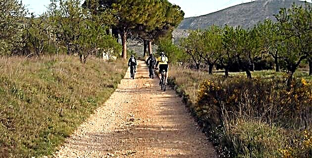
The volcano is 5 kilometers away, so at 8:30 in the morning we set off to take advantage of the cool morning. We have traveled barely half a kilometer when Pascual, our guide, points out the esplanade that we crossed at that moment and mentions "Here was the town before the eruption. Of what was a prosperous community of 300 inhabitants, no trace remains.
From this point it becomes clear that the region's ecosystem was radically transformed. Where once there were fields, streams and a thick forest in which animal life proliferated, today there are hills and extensive plains covered with boulders, pebbles and sand, covered with little vegetation. When approaching the mountain from the east side, the impression of grandeur is limitless. The slopes do not reach more than 500 m of unevenness, so the ascent is relatively smooth and by eleven in the morning we are already 300 m from the summit of the volcano.
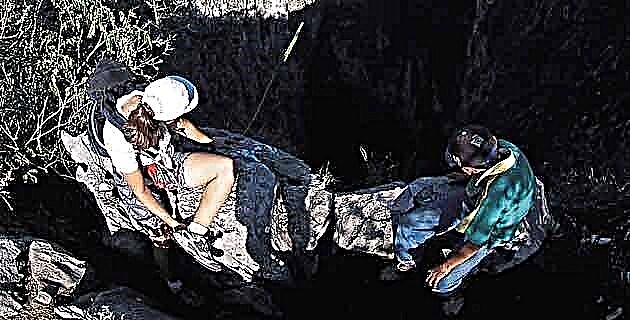
The crater is a huge “bowl” one kilometer in diameter at the bottom of which is a beautiful lake of yellow-green water. On the right bank of the lake we see fumaroles and clouds of steam from which a slight smell of sulfur emerges. Despite the considerable distance, we can clearly hear the pressurized steam escaping.
Descending to the bottom of the crater takes us 30 minutes. It's hard to conceive of such a grandiose setting; the size of the "bowl" could be compared to the area of ten football stadiums, with steep walls that rise 130 m high. The smell of sulfur, the fumaroles and the streams of boiling water remind us of images of a primitive world that we have already forgotten.
Right in the center of the crater, the lake sparkles like a jewel in the rays of the sun. Its approximate dimensions are 500 m long by 300 wide and with an average depth of 1.5 m that varies according to the dry and rainy season. The peculiar tonality of the water is due to the content of minerals, mainly sulfur, and the sediment that is continuously removed by the fumaroles. Three of my companions do not miss the opportunity to take a dip and dive into the warm waters, whose temperature fluctuates between 33º and 34ºC, although it usually rises to 56º.
In addition to its scenic beauty, the tour of the crater offers us interesting surprises, especially in the extreme northeast, where intense hydrothermal activity is manifested with pools and boiling water springs; fumaroles that produce steam emissions rich in hydrogen sulfide; solfataras, from which sulfur gas emanates, and geysers that offer an impressive sight. When walking in this area we take extreme precautions, since the average temperature of the steam is 100 ° C, but it occasionally exceeds 400 degrees. Special care must be taken when examining “vaporizing floors” - steam jets escaping from cracks in the rock - as the weight of a person can cause subsidence and expose the boiling water circulating below them.
For the inhabitants of the region, the eruption of El Chichonal was terrible and had devastating effects. Although many of them abandoned their properties in time, others were surprised by the rapidity of the phenomenon and were isolated due to the rain of tephra and lappilli - ash and rock fragments - that covered the roads and prevented their exit. The ash fall was followed by the expulsion of pyroclastic flows, avalanches of burning ash, fragments of rock and gas moved at very high speed and rushed down the slopes of the volcano, burying several villages under a 15-meter-thick layer. of dozens of settlements, as happened to the Roman cities of Pompeii and Herculaneum, which in AD 79 suffered the eruption of the volcano Vesuvius.
Currently El Chichonal is considered a moderate active volcano and, for this reason, specialists from the Institute of Geophysics of UNAM systematically monitor steam emissions, water temperature, seismic activity and other parameters that can warn of an increase in the volcanic activity and the possibility of another eruption.
Little by little life has returned to the area; the mountains that surround the volcano have been covered with vegetation thanks to the great fertility of the ashes and the characteristic fauna of the place has repopulated the jungle. A short distance away new communities arise and with them the hope that El Chichonal, this time, will sleep forever.
TIPS FOR THE EXCURSION
Pichucalco has a gas station, restaurants, hotels, pharmacies and shops. It is convenient to stock up here with everything you need, since in the following locations the services are minimal. As for clothing, it is advisable to wear long pants, cotton shirt or shirt, cap or hat, and boots or tennis shoes with rough soles that protect the ankle. In a small backpack, each hiker must carry a minimum of four liters of water and food for a snack; chocolates, sandwiches, apples, etcetera, and the camera should not be forgotten.
The author of the article appreciates the valuable support provided by the company La Victoria.
IF YOU GO TO EL CHICHONAL
Leaving from the city of Villahermosa, take federal highway no. 195 towards Tuxtla Gutiérrez. On the way you will find the towns of Teapa, Pichucalco and Ixtacomitán. In the latter, follow the deviation towards Chapultenango (22 km) until you reach Colonia Volcán El Chichonal (7 km). From this point you must walk 5 kilometers to reach the volcano.
Source: Unknown Mexico No. 296 / October 2001